
Area 34.59 km² | Region Occitanie Intercommunality Nord du Bassin de Thau Local time Thursday 4:12 PM | |
 | ||
Weather 12°C, Wind SW at 14 km/h, 76% Humidity Points of interest Étang de Thau, Musée‑Parc des Dinosaures, Domaine de Belle Mare | ||
M ze vu du ciel
Mèze (Phoenician: Mansa, in occitan Mesa) is a commune in the Hérault department in southern France.
Contents
- M ze vu du ciel
- Map of 34140 MC3A8ze France
- Le corso de m ze
- Geography
- History
- Sights
- Personalities
- Festivals
- Traditions
- References
Map of 34140 M%C3%A8ze, France
Its inhabitants are called Mézois.
Le corso de m ze
Geography
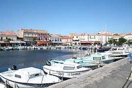
Situated on the étang de Thau, Mèze shares with Bouzigues its historic role as the oyster capital of the area. Almost a third of its inhabitants depend on the fishing industry for their livelihood. In recent years, tourism and transport have become increasingly central to the local economy.
History
An important port since Phoenician times, Mèze has always primarily been a fishing town. During the Roman Empire, the town lay on the main Southern route from Italy to Spain - the 'Via Domitia'.The Romans brought wine to the area and left a legacy of architecture including two of the town's churches. The production of shellfish, especially oysters, has been the mainstay of the Mèze economy for almost a century and the whole Basin de Thau area has built an international reputation for the quality of its seafood.