
Rank Village Area 27.7 km² Population 896 (1 Jan 2008) Area code 72 | Time zone CET (UTC+1) Local time Thursday 2:07 PM Postal code 7304 KSH code 33923 | |
 | ||
Weather 21°C, Wind SW at 13 km/h, 41% Humidity | ||
Settings
Mánfa is situated in the Mecsek Mountain sin Southern Hungary. It can be reached by car along the No. 66 highway in the Kaposvár–Sásd–Magyarszék–Pécs line.
History
The village is an old foundation from the Árpád age. In 1949 another village, Budafa was attached to it, and the united village was attached to the town of Komló, a mining town near Pécs. In 1991 people of Mánfa voted to separate from Komló and recently Mánfa is an independent village.
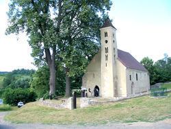
Sightseeings
References
Mánfa Wikipedia(Text) CC BY-SA