
Established 1702 Time zone EET (UTC+2) Area 18.5 km² | Elevation/(average value of) 346 m (1,135 ft) Postal code 82486 | |
 | ||
Lysovychi (Ukrainian: Лисо́вичі ) is a village in Stryi Raion, Lviv Oblast in western Ukraine.
Local government is administered by Lysovytska village council.
The population of the village is about 1770 people.
Contents
- Map of Lysovychi Lvivska Ukraine
- Geography
- History
- Monuments of architecture
- Personalities
- Literature
- References
Map of Lysovychi, Lvivska, Ukraine
Geography
The village is located in the Carpathian Foothills and is located at a distance of 17 kilometres (11 mi) from the district center of Stryi along the road Highway H10 (Ukraine) (H10) from Stryi to Chișinău and 88 kilometres (55 mi) from the regional center of Lviv, 84 kilometres (52 mi) from the regional center of Ivano-Frankivsk (administrative center of Ivano-Frankivsk Oblast).
And this village is located on the altitude of 346 metres (1,140 ft) above sea level.
History
The first written mention dates back to year 1702. According to other sources Lysovychi were first mentioned in written sources in 1371. During the First World War, the village was the scene of fierce fighting, the ground was burned, crops destroyed.
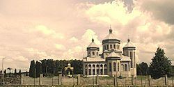
Monuments of architecture
The village has two sights of architecture Stryi district: