
- max 80 m/s (2,825 cu ft/s) Length 7 km Basin area 178 km² Mouth elevation 0 | - average 4.0 m/s (141 cu ft/s) - min 0.5 m/s (18 cu ft/s) Discharge 4 m³/s | |
 | ||
Lysakerelven (also known as Lysakerelva, English: Lysaker River) is a river in Norway that forms the boundary between the municipalities of the capital city of Oslo and Bærum.
Contents
Map of Lysakerelven, Norway
The river by this name has its source in Bogstadvannet, though the source is further up, at Langlivann, and Søndre and Nordre Heggelivann in Oslomarka, the forests surrounding Oslo. Consequently, it is considered part of Oslomarkvassdragene, the river system flowing through these forests, and more specifically Sørkedalsvassdraget, the valley above Bogstadvannet. It flows out into Lysakerfjorden, part of Oslofjorden near Lysaker.
History
There is evidence that the river has been used for mills since the 12th century, and probably earlier. The old name of the river was Få (Norse Fǫð), which means "fence" or "boundary". In the 18th century, Bogstadvannet was also known as Faavandet.
By 1660, twelve farms had claims to the hydromechanical power generated by the river. These farms, several of which have since given names to neighborhoods in Aker (now Oslo) and Bærum, were:
From Bogstadvannet going south, there are several sites of historical significance.
Osdammen
Osdammen was a dam with a resident mill for the sawmill at Bogstad. There is evidence that there was a sawmill at this site going back as far as the 16th century. Sources also suggested it delivered lumber for reconstruction in London after the Great Fire in 1666. The mill was in operation until 1915, when the owners at Bogstad agreed with the mill owner at Grini, Løvenskiold, to shut down the mill in return for enough electricity to set up a sawmill at Zinoerbrua.
Fossum Jernverk
A mill with a finery forge and trip hammer were established here around 1780 by Conrad Clausen, the owner of Bærum Jernverk (Bærum Ironworks). The forge was situated on the Bærum side and measured 30 by 19 Norwegian ells (about 18 meters by 12 meters). It had an annual capacity of about 250 tons of wrought iron. The pig iron originated in Southern Norway, whence it was transported by ship and unloaded at the dock at Vækerø before being pulled by horse and cart to the mill.
Recreation
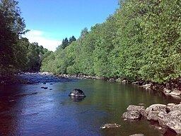
The river is 7.4 kilometres (4.6 mi) long, with a total fall of 145 metres (476 ft). It includes several smaller rapids and waterfalls, the most prominent of these being Granfossen, often known as Fåbrofossen. In later years, the area around the river has been developed as a recreational area, and a footpath follows the entire length of the river on both the Oslo and Bærum sides, so that it is possible to hike around the entire river, from the Oslofjord to Bogstadvannet on one side, and back on the other. Further, the footpath connects to the network of paths throughout the forests outside Oslo, and those around the Oslofjord. The path on the Oslo side is also suitable for cycling. The terrain and scenery is quite varied along the footpaths, ranging from significant hills to flat and undulating stretches. Some of the rapids are strong enough that the river is used for kayak training; other places swimming has become popular.