
Country Norway District Helgeland Area rank 291 in Norway Local time Wednesday 6:51 AM Official language form Bokmål | County Nordland Administrative centre Lurøy Demonym(s) Lurøyværing Population 1,912 (2011) | |
 | ||
Weather 4°C, Wind W at 40 km/h, 80% Humidity Area 264.6 km² (257.6 km² Land / 6.92 km² Water) Points of interest Omega, Hauglandstranda, Svesanden, Liastranda, Pollen | ||
Lurøy is a municipality in Nordland county, Norway. It is part of the Helgeland traditional region. The administrative centre of the municipality is the village of Lurøy, located on the island of Lurøya. Other villages include Aldra, Haugland, Konsvikosen, Lovund, Sleneset, Stokkvågen, and Tonnes.
Contents
- Map of LurC3B8y Norway
- General information
- Name
- Coat of arms
- Churches
- Geography
- Government
- Municipal council
- Media gallery
- References
Map of Lur%C3%B8y, Norway
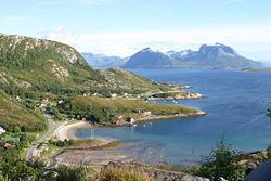
The municipality is located on the coast just south of the Arctic circle, on the western edge of the Saltfjellet mountain range. The Lurøygården (Lurøy Farm) on Lurøya is a more-than-200-year-old renaissance garden with old plants, a pool, and a nearly 20-metre (66 ft) high Copper Beech.
General information
Lurøy was established as a municipality on 1 January 1838 (see formannskapsdistrikt). On 1 January 1872, the far western island district (population: 289) was separated from Lurøy to become the new municipality of Træna. This left Lurøy with 1,554 residents. The borders of Lurøy have not changed since that time.
Name
The municipality (originally the parish) is named after the island of Lurøya (Old Norse: Lúðrøy), since the first church was built there. The first element is lúðr which means "hollowed log" (here probably referring to the form of the mountain of the island). The last element is øy which means "island".
Coat-of-arms
The coat-of-arms is from modern times; they were granted on 22 August 1986. The arms show a black buoy on a gold background. The buoy is an appropriate symbol for a municipality since it is dependent on fishing and sailing.
Churches
The Church of Norway has two parishes (sokn) within the municipality of Lurøy. It is part of the Nord-Helgeland deanery in the Diocese of Sør-Hålogaland.
Geography
Lurøy is located on the western coast of Helgeland. The small strip of mainland Lurøy runs from Tonnes in the north along Norwegian County Road 17 to Stokkvågen along the Sjona fjord in the south. The rest of the municipality is located on 1,375 islands located to the west of the mainland. The major islands include Aldra, Lurøya, Onøya, Stigen, Solvær, and Lovund. There are also two islands in the northern part of Lurøya that are divided between Lurøy and neighboring Rødøy municipality: Nesøya and Hestmona.
Government
All municipalities in Norway, including Lurøy, are responsible for primary education (through 10th grade), outpatient health services, senior citizen services, unemployment and other social services, zoning, economic development, and municipal roads. The municipality is governed by a municipal council of elected representatives, which in turn elect a mayor.
Municipal council
The municipal council (Kommunestyre) of Lurøy is made up of 19 representatives that are elected to every four years. Currently, the party breakdown is as follows: