
District n.a. Elevation 715 m Population 2,049 (31 Dec 2008) | SFOS number 1405 Local time Wednesday 4:53 AM Postal code 6078 | |
 | ||
Surrounded by Brienzwiler (BE), Giswil, Hasliberg (BE), Hofstetten bei Brienz (BE), Kerns, Meiringen (BE), Sachseln Website www.lungern.ch SFSO statistics Weather 2°C, Wind NE at 2 km/h, 77% Humidity | ||
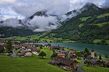
Lungern is a municipality in the canton of Obwalden in Switzerland. Lake Lungern is located within the municipality. Besides Lungern itself, the municipality includes the settlements of Bürglen, Kaiserstuhl and Obsee.
Contents
- Map of Lungern Switzerland
- Geography
- History
- Population and Economy
- Demographics
- Economy
- Historic population
- Weather
- Churches
- Leisure time
- Transport
- References
Map of Lungern, Switzerland
Geography
The village of Lungern lies 750 metres (2,460 ft) above sea level in the highest part of the canton of Obwalden, on the eastern shore of the Lake of Lungern and at the foot of the Brünig Pass. It is the highest village of the Sarneraa-Valley, and is situated in a basin that is open only to the north and is surrounded on all other sides by steep and woody inclinations and rocks.
To the south-west the municipality extends to the Brünig Pass. On its north-western side, the municipal boundary is set by the Wilerhorn and Höch Gumme mountains, and includes the whole of the Lake of Lungern. To the east, the boundary reaches as far as the Hochstollen and Chingstuel mountains, and includes the Güpfi mountain and part of the Kleine Melchtal valley.
Besides the village of Lungern, the municipality includes the settlements of Kaiserstuhl and Bürglen that lie at the northern end of the lake, and Obsee on the south-western end of the lake. The hamlet of Obsee might be the best maintained part of the old village, where you will still find old houses in their original structure and style.
The municipal district of Lungern has an area of 46.33 square kilometres (11,450 acres), of which 6.48 square kilometres (1,600 acres) are meadow and tilled land, 19.2 square kilometres (4,700 acres) are pastureland, 15.97 square kilometres (3,950 acres) are wooded and the remaining 2.91 square kilometres (720 acres) are unproductive.
History
The first legal proof of Lungern's existence is contained in a tax register for the diocese of the bishop of Konstanz in Germany dating from the year 1275. It is mentioned as Lutigern and also as de Lungern.
In 1861 it became easier to reach the village with the construction of the old road over the Brünig pass. A quarter century later, in 1886, the first mail carriages came over the pass. However, this only lasted two years, in 1888 the railroad from Brienz to Alpnachstad (now part of Alpnach) opened. In 1887 the Eibach river flooded causing damage to the old village church. Six years later, in 1893, was the consecration of the neo-gothic style church. At the end of the 18th century the population of Lungern lowered the level of the lake, with great effort and over many years, in order to improve living conditions. The works created new land for agriculture, housing, and a sawmill. Within 80 years the hard-won land was lost to a new dam: in 1922 a company named CKW built and started running a power station located at the lake. Nowadays the local power station (EWO) produces electricity from the power of the water of the Lungerersee. In 1942 the railroad line over the Brünig pass was electrified.
Population and Economy
Nowadays the village of Lungern has about 1950 inhabitants. The population is stable, so there is a rise in the ratio of elderly to total population. In fact 17.5% of the total population of Lungern are of a pensionable age, compared with an average of 12% in the canton. If work opportunities remain limited this will likely grow even further in the future.
Demographics
Lungern has a population (as of 31 December 2015) of 2,142. As of 2007, 8.6% of the population was made up of foreign nationals. Over the last 10 years the population has grown at a rate of 2.6%. Most of the population (as of 2000) speaks German (94.8%), with Albanian being second most common ( 2.2%) and French being third ( 0.7%). As of 2000 the gender distribution of the population was 49.7% male and 50.3% female. As of 2000 there are 681 households in Lungern.
In the 2007 federal election the most popular party was just classed as other, which received 41.7% of the vote. The next three most popular parties were the SVP (26.2%), the CVP (25.6%) and the SPS (6.5%).
In Lungern about 71.5% of the population (between age 25-64) have completed either non-mandatory upper secondary education or additional higher education (either university or a Fachhochschule).
Economy
Lungern has an unemployment rate of 0.6%. As of 2005, there were 156 people employed in the primary economic sector and about 66 businesses involved in this sector. 443 people are employed in the secondary sector and there are 27 businesses in this sector. 394 people are employed in the tertiary sector, with 54 businesses in this sector. About 24% of the workers are involved in agriculture and forestry, 40% are considered artisans or craftsman. Of the rest of the working population, 13% are in commercial business or teaching staff, 12% are self-employed and 11% are domestic and hotel employees.
Economically, agriculture, forestry and wood-working are predominant. Agriculture comprises cattle-breeding and dairy-farming. All of the agricultural farms are cultivated by native highlanders, and they are mainly situated not in the bottom of the valley but on its slopes.
Historic population
The historical population is given in the following table:
Weather
Lungern has an average of 149.5 days of rain per year and on average receives 1,491 mm (58.7 in) of precipitation. The wettest month is August during which time Lungern receives an average of 163 mm (6.4 in) of precipitation. During this month there is precipitation for an average of 14.4 days. The month with the most days of precipitation is June, with an average of 14.7, but with only 158 mm (6.2 in) of precipitation. The driest month of the year is October with an average of 88 mm (3.5 in) of precipitation over 14.4 days.
Churches
There is one Catholic church and one chapel. The church is fairly new, about 110 years old, because the old one was destroyed in a flood of the lake.
Leisure time
The main sights of Lungern are:
Transport
The Brünig railway line passes through the municipality, on its route between Interlaken and Lucerne. Both Lungern station and Kaiserstuhl OW station are on the line and in the municipality, both being served by one train per hour in each direction.