
OS grid reference NO291365 Sovereign state United Kingdom Postcode district DD2 Dialling code 01382 Lieutenancy area Angus | Post town DUNDEE Council area Angus | |
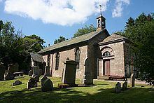 | ||
Winter drive to parish church lundie angus scotland
Lundie is a parish and small hamlet in Angus, Scotland, 10 miles (16 km) northwest of Dundee, situated at the head of the Dighty valley in the Sidlaws, off the A923 Dundee to Coupar Angus road. The name Lundie probably derives from the Gaelic "lunnd" or "lunndann", meaning "little marsh", although "lon dubh" ("black marsh" or even "linn dei" (water of God") have also been proposed. Lundie is surrounded by several small lochs, whose size has been reduced in recent times by agricultural drainage, hence largely draining the eponymous marshes. Dorward states that in 1203 Walter of Lundie gave 20 acres (81,000 m2) of land to the prior and canons of St Andrews. Lundie Castle, now just a few stones, was probably built in the sixteenth century on a hill to the east. The population of Lundie has declined from 448 in 1841 to under a hundred now; the shops and alehouses closed some time ago, the fairs are no longer held, and the school was closed in 1967.
Contents
- Winter drive to parish church lundie angus scotland
- Map of Lundie Dundee UK
- Winter view parish church lundie angus scotland
- Lundie in myth
- References
Map of Lundie, Dundee, UK
Lundie is notable for being the burial place of Adam Duncan, 1st Viscount Duncan. The churchyard of Lundie church contains an Abraham and Isaac stone. Although the church is an ancient foundation, it was drastically restored in 1847. Nearby Lundie Crags (353 m, OS reference NO 282 378) are a popular walking destination.
Winter view parish church lundie angus scotland
Lundie in myth
Sir James the Rose was supposedly killed on a grassy bank near Lundie Craigs.