
Width 2.5 km (1.55 mi) Highest point Lovundfjellet Area 47 ha | Length 3 km (1.9 mi) Highest elevation 623 m (2,044 ft) Local time Tuesday 4:53 AM | |
 | ||
Weather 6°C, Wind S at 29 km/h, 87% Humidity | ||
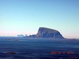
Lovund is an island and village in the municipality of Lurøy in Nordland county, Norway. The island is located west of the Solvær islands and southeast of Træna. Lovund is notable for the large puffin breeding colony located on the rocky north slope of the island.
Contents
Map of 8764 Lovund, Norway
The village of Lovund (sometimes called Strand) is located in the northeastern part of the island. The 0.45-square-kilometre (110-acre) village has a population (2013) of 426. The population density is 933 inhabitants per square kilometre (2,420/sq mi). Lovund Church, located in the village, serves the people of the island.
Name
The Old Norse form of the name might have been Laufund. The first element is then lauf which means "leaf" or "broad-leaved trees", referring to the fact that the western part of the island is covered with a forest. The last element is the suffix -und meaning "land" (see Borgund).