
South end: LA 10 in Sheridan Length 19.12 km | Parishes: Washington | |
 | ||
Existed: 1955 renumbering – present Parish | ||
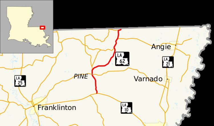
Louisiana Highway 62 (LA 62) is a state highway located in Washington Parish, Louisiana. It runs 11.88 miles (19.12 km) in a north–south direction from LA 10 in Sheridan to the Mississippi state line north of State Line.
Contents
Map of LA-62, 5, LA, USA
The route connects the small rural communities of Pine and State Line with LA 10, the main east–west route through Washington Parish. LA 10 leads to Bogalusa, the parish's largest city, as well as Franklinton, the parish seat. LA 62 follows a slightly winding route from southwest to northeast, but it serves a generally north–south function and is bannered accordingly.
Route description
From the south, LA 62 begins at an intersection with LA 10 at a point known as Sheridan. LA 10 connects to Franklinton on the west and Bogalusa on the southeast. LA 62 proceeds north through a sparsely populated pine forest for 2.9 miles (4.7 km) before intersecting LA 436 in the small community of Pine. LA 436 parallels the route of LA 10 between Franklinton and a point north of Bogalusa. 0.6 miles (0.97 km) later, LA 62 curves to the northeast while LA 424 continues the route northward toward Thomas.
Over the next 5.1 miles (8.2 km), LA 62 makes a long northeastern curve through an area of mixed pine forest and horse farms before intersecting LA 438, another route connecting to Thomas on the west. LA 62 and LA 438 run concurrently for the next 1.5 miles (2.4 km) to an area known as State Line, where LA 438 turns east toward Angie. 1.2 miles (1.9 km) north of this junction is a second intersection with LA 424, at which LA 62 briefly curves to the east. Shortly after resuming its northeastern course, LA 62 reaches the Louisiana–Mississippi state line. The highway continues into Walthall County, Mississippi as a local road known as Old State Line Road, which leads toward Mississippi Highway 48 (MS 48) southeast of Tylertown.
LA 62 is classified as a rural major collector by the Louisiana Department of Transportation and Development (La DOTD). The posted speed limit is generally 55 mph (90 km/h), reduced to 45 mph (70 km/h) through Pine. Average daily traffic volume in 2013 is reported as 2,200 vehicles between Sheridan and Pine, decreasing to 1,150 between Pine and State Line, and again to 780 north of State Line. LA 62 is an undivided two-lane highway for its entire length.
History
In the original Louisiana Highway system in use between 1921 and 1955, the modern LA 62 was part of three separate state highways. State Route 754 followed the route from the southern terminus to Pine, where it continued north along the present LA 424. State Route 469 followed the remainder of the route, briefly running concurrent with Route 754 before turning northeast toward State Line. Additionally, the portion of the highway immediately south of State Line was also part of State Route 262, which duplicated the modern LA 438 concurrency. All three routes were designated by the state legislature between 1928 and 1930 and remained in effect until the 1955 Louisiana Highway renumbering.
LA 62 was created in the 1955 renumbering, giving the Sheridan-State Line route a single highway designation.
La 62—From a junction with La 10 at or near Sheridan through or near Pine and State Line to the Mississippi State Line.
The route of LA 62 has remained the same to the present day.
Major intersections
The entire highway is in Washington Parish.