
Length 264.9 km | ||
 | ||
Existed: 1955 renumbering – present West end: US 71 north of Loggy Bayou Parishes Bienville Parish, Louisiana, Jackson Parish, Louisiana | ||
Along louisiana highway 44 jefferson hwy the great river road national scenic hwy in reserve
Louisiana Highway 4 (LA 4) is a state highway located in northern Louisiana that runs 164.6 miles (264.9 km) in a west–east direction from U.S. Highway 71 (US 71) near Loggy Bayou to LA 605 in Newellton.
Contents
- Along louisiana highway 44 jefferson hwy the great river road national scenic hwy in reserve
- Map of LA 4 Louisiana USA
- Western terminus to Jonesboro
- Jonesboro to Winnsboro
- Winnsboro to Newellton
- History
- References
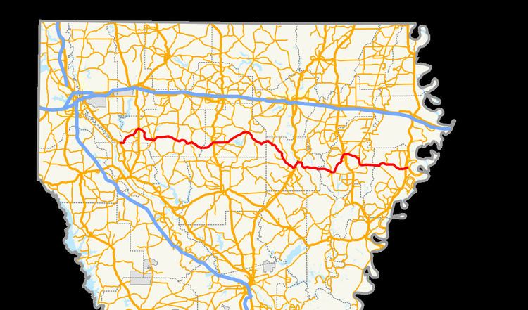
Map of LA-4, Louisiana, USA
The entire route parallels Interstate 20 (I-20) an average of about 20 miles (32 km) to the south. Along the way, it serves the city of Winnsboro and smaller towns such as Ringgold, Jonesboro, Chatham, Columbia, and Newellton (its eastern terminus). It also intersects many of the state's major north–south routes, such as US 71 (its western terminus), US 371, US 167, US 165, US 425, and US 65.
Though it runs primarily west–east, LA 4 meanders along rural roads for virtually its entire distance, bending considerably to the north and south in order to pass through the center of various towns. LA 4 travels through five parishes, connecting the parish seats of the middle three (Jackson, Caldwell, and Franklin). Not quite a cross-state route, it begins at US 71 southeast of the Shreveport–Bossier City Metropolitan Area about 36 miles (58 km) east of the Texas state line and does not reach I-49, north and central Louisiana's only north–south interstate. Its eastern terminus, however, comes within 5 miles (8.0 km) of the Mississippi state line at the Mississippi River.
Several long sections of LA 4 are part of the state-designated system of tourist routes known as the Louisiana Scenic Byways. The portion of the route from LA 557 at Vixen to LA 559 east of Columbia - excluding the concurrency with US 165 through Columbia - is part of the Bienville Trace Scenic Byway. The portion of the route from Winnsboro to LA 128 east of the Tensas River is part of another leg of the same byway.
Western terminus to Jonesboro
From the west, LA 4 begins at an intersection with US 71 at the extreme southwest corner of Bienville Parish. It proceeds east as a two-lane, undivided highway and runs along the Red River Parish line for 1.7 miles (2.7 km) before curving to the northeast toward Ringgold. After 6.2 miles (10.0 km), it intersects LA 790, which heads southeast to US 371 at Tullis. 2.2 miles (3.5 km) later, LA 4 enters Ringgold on Mill Street where it intersects LA 154 (School Street). The two highways proceed in a concurrency to the town's main junction at US 371 (Military Road), which connects to Minden on the north and Coushatta on the south. After making a brief jog south onto US 371, LA 4 and LA 154 turn east onto Bienville Road. At the eastern edge of town, LA 154 branches off to the northeast through Jamestown while LA 4 proceeds southeast for 8.9 miles (14.3 km) to Castor. Here it intersects LA 792, which also connects to Jamestown, and briefly turns southeast, continuing the route of that highway to the village's main junction. At a four-way intersection, LA 153 continues the route southeast to Ashland; LA 507 proceeds southwest toward Womack; and LA 4 turns northeast co-signed with LA 507 for one block until the latter turns north onto Kepler Road.
Leaving Castor, LA 4 proceeds in a general eastern direction for 11.2 miles (18.0 km) where it intersects LA 9 in an area known as Lucky. The immediate destinations of LA 9 are Bienville to the north and Saline to the south. 5.8 miles (9.3 km) later, LA 4 intersects LA 155, also connecting to LA 9 at Saline, and the two highways proceed in a concurrency to a point known as Friendship. Here, LA 501 heads south toward Calvin, and shortly thereafter, LA 155 splits off to the north toward Liberty Hill. Meanwhile, LA 4 curves to the southeast through Danville, a point on the Kansas City Southern Railway (KCS), and crosses the Dugdemona River into Jackson Parish 3.3 miles (5.3 km) later.
Jonesboro to Winnsboro
5.3 miles (8.5 km) inside the parish line, LA 4 enters Jonesboro, the parish seat, and widens to an undivided, four-lane highway. It then turns east from South Cooper Street onto East Main Street, a divided, two-lane street, and passes through the center of town. After crossing the KCS tracks, LA 4 intersects the concurrent US 167 and LA 147. US 167 connects to Ruston on the north and Winnfield on the south. After this junction, LA 4 narrows to an undivided, two-lane highway and continues due east out of town for 5.0 miles (8.0 km) to Weston, where it intersects LA 811 (Gladway Road) and, 1.0 mile (1.6 km) later, LA 505. Following the latter intersection, LA 4 curves to the northeast for 9.7 miles (15.6 km) and crosses the Caney Creek Reservoir before entering the town of Chatham. Running through town on Shell Avenue, it intersects LA 146, another route into Ruston, and curves to the southeast. It then intersects LA 34, which heads to Winnfield on the south and the major city of Monroe to the northeast. Continuing southeast for 5.5 miles (8.9 km), LA 4 intersects LA 499 at a point near Hoods Mill and heads in a general eastward direction into Caldwell Parish.
After crossing the parish line, LA 4 curves to the southeast and intersects LA 557 at a point known as Vixen. 9.4 miles (15.1 km) later, LA 4 intersects LA 846 at Mount Pleasant. After a brief concurrency, LA 846 splits off to the north, running parallel to LA 4 toward the previous junction with LA 557. 2.4 miles (3.9 km) later, LA 4 intersects LA 3239, a gravel road that connects to LA 126 west of Grayson. After another 2.6 miles (4.2 km), LA 4 intersects LA 850 at Pulpwood Spur then curves to the northeast across the Union Pacific Railroad (UP) tracks to US 165 at Banks Springs, just north of Grayson. LA 4 turns northeast to follow US 165, becoming an undivided, four-lane highway (with middle turning lane) into Columbia, the parish seat, intersecting LA 849 on the way. In Columbia, US 165 and LA 4 cross a high-level bridge over the Ouachita River, after which LA 4 resumes its eastward course as an undivided, two-lane highway while US 165 continues north toward Monroe. Opposite a bend in the river, LA 4 intersects LA 133 and curves to the southeast, running roughly parallel to the river for 3.3 miles (5.3 km). LA 4 then turns back to the east while LA 559 continues south along the river. 5.7 miles (9.2 km) later, LA 4 crosses the Boeuf River into Franklin Parish after passing through the Boeuf Wildlife Management Area.
Continuing east for 6.5 miles (10.5 km), LA 4 reaches LA 135, the first of three junctions in an area known as Fort Necessity. Shortly afterward, LA 562 heads south and loops to the east across Turkey Creek Lake to Wisner, and finally, LA 128 heads east to Gilbert on US 425/LA 15. At this last junction, LA 4 curves to the northeast toward Winnsboro. After 6.1 miles (9.8 km), LA 4 intersects LA 865 at a point known as Brownell, followed 2.2 miles (3.5 km) later by LA 3201 (Riser Road), a connector to US 425/LA 15 on the south edge of Winnsboro.
Winnsboro to Newellton
LA 4 enters Winnsboro, which serves as the parish seat, and runs along Prairie Road. LA 4 then reaches the main thoroughfare, Front Street, an undivided, four-lane roadway (with middle turning lane) and part of the concurrent US 425 and LA 15. LA 4 turns northwest onto Front Street, adding to the concurrency for a few blocks, to a four-way intersection where US 425 and LA 15 continue north toward Bastrop and Monroe, respectively; LA 130 heads west along Taylor Avenue; and LA 4 takes a sharp turn east onto Kinloch Street, becoming an undivided, two-lane highway once again. This intersection also marks the western terminus of LA 17, which follows LA 4 east out of Winnsboro. Before exiting the city, LA 4 and LA 17 intersect the northern segment of LA 865 (Pine Street) and LA 864 (Loop Road), another connector to US 425/LA 15. Shortly after crossing the city limits, LA 17 splits off to the north toward Crowville.
After 3.3 miles (5.3 km), LA 4 intersects LA 863, which connects to LA 578 a short distance away. LA 4 turns to the southeast and intersects LA 578 itself, continuing the route of that highway south to a point known as Como, where it intersects and begins a concurrency with LA 128 northeast of Gilbert. Briefly following along a bend in Bayou Macon, LA 4 and LA 128 intersect LA 555, which travels northward along the bayou. Just east of the bayou is an intersection with LA 572 at Lorelein. 3.7 miles (6.0 km) east of this intersection, LA 4 and LA 128 cross the Tensas River into Tensas Parish.
2.1 miles (3.4 km) inside the parish line, LA 128 splits to the southeast toward St. Joseph. LA 4 proceeds eastward along the Tensas River for a short distance to LA 888 then continues for another 7.9 miles (12.7 km) to LA 575. Shortly afterward, LA 4 enters the town of Newellton, its final destination, and intersects US 65, which heads north to Tallulah and south to Ferriday. LA 4 follows Verona Street in Newellton and reaches its eastern terminus at LA 605 (Main Street), which runs along Lake St. Joseph, an ox-bow lake of the Mississippi River.
History
In the original Louisiana Highway system in use between 1921 and 1955, the modern LA 4 made of parts of several routes, including: State Route 13 from the western terminus at US 71 to Ringgold; State Route 417 to Castor; State Route C-2203 to Friendship; State Route 13 again to Chatham; LA 17 to Winnsboro; State Route 16 east out of Winnsboro; State Route 48 to the modern junction with LA 128 east of the Tensas River; and State Route 76 to the eastern terminus in Newellton.
LA 4 was created with the 1955 Louisiana Highway renumbering, and its route has remained the same apart from a shift onto a new bridge at Columbia in Caldwell Parish.
In Columbia, LA 4 and US 165 originally curved slightly to the northeast at Church Street and crossed a vertical lift bridge over the Ouachita River. It then rejoined the location of the current alignment just south of the intersection where LA 4 turns eastward, separating from US 165. This bridge, built in 1935, was replaced by the current four-lane, high-level span in 2007. This construction was part of a larger project to widen US 165 to four lanes throughout the state of Louisiana, completed in 2012. The original bridge has been demolished, but the approaches still exist as local roads.