
Length 87.4 km | ||
 | ||
Existed: 1955 renumbering – present Parishes | ||
Louisiana Highway 39 (LA 39) is a state highway in Louisiana that serves Orleans, St. Bernard, and Plaquemines Parishes. In New Orleans, LA 39 is referred to as North Claiborne Avenue, while in St. Bernard Parish, it is known as Judge Perez Drive. It spans 54.08 miles (87.03 km) and is bannered north/south.
Contents
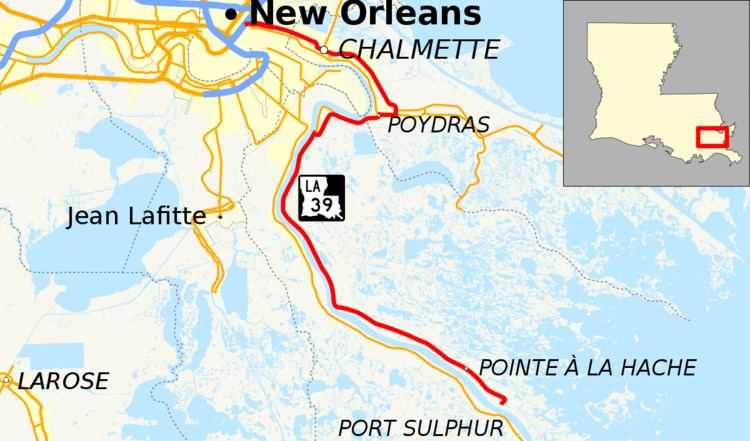
Map of LA-39, Louisiana, USA
Route description
From the north, LA 39 begins at an exit ramp from Interstate 10 onto North Claiborne Avenue. In New Orleans, Highway 39 is a four lane, divided road that runs through the city's 9th Ward. LA 39 crosses over the Industrial Canal via the Claiborne Avenue Bridge and enters the Lower 9th Ward, where it becomes the neighborhood's primary road. At the parish line, LA 39 becomes West Judge Perez Drive and passes through the towns of Arabi, Chalmette, Meraux and Violet. When LA 39 intersects with LA 47, it becomes East Judge Perez Drive. After exiting Meraux, LA 39 continues parallel to the Mississippi River and shortly merges with LA 46 near Poydras. At the two highways' merging, LA 39 becomes a two lane, undivided road. It runs due west and then southward along the east bank of the Mississippi River into Plaquemines Parish and passes through Pointe à la Hache before reaching a dead end at the Bohemia Spillway Levee.
History
Early Louisiana maps show that the road continued beyond its current southern terminus to Fort St. Philip, yet it is unsure if this road were built and of what quality. Between Braithewaite and Scarsdale, LA 39 bypassed English Turn, and the original route is now LA 3137.