
Existed: 1924 – present Length 313 km | Constructed 1924 | |
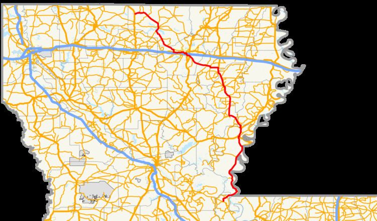 | ||
North end: US 167 / US 63 in Lillie | ||
Louisiana Highway 15 (LA 15) is a state highway in Louisiana. It spans 194.52 miles (313.05 km), serving northeastern Louisiana, providing direct access to US 84 and Baton Rouge.
Contents
Map of LA-15, Louisiana, USA
Route description
LA 15 begins as an exit from U.S. Route 167 just south of Lillie and heads due east towards Spearsville. From Spearsville, LA 15 turns to the southeast and shortly merges with LA 2 and LA 33 in Farmerville. LA 15 then turns southeastward again, leaves Union Parish, and enters Ouachita Parish. LA 15 then heads due south and merges with U.S. Route 80. U.S. 80/LA 15 then turns east through Claiborne, West Monroe and turns southeast and intersects with Interstate 20, southwest of downtown Monroe. It then meets US 165 before meeting LA 831, also known as Prairie Road.
LA 15 continues east-southeast through Ouachita Parish and passes through rural Richland Parish, where LA 15 crosses the Boeuf River on a historic truss bridge, dating from 1939. It then turns due south and is joined by U.S. Route 425 near Archibald, in a concurrence which continues to Ferriday.
On the way to Ferriday, while in Franklin Parish, LA 15 passes through Baskin, Winnsboro, Gilbert, and Wisner. LA 15 then enters Catahoula Parish, where it passes through the town of Sicily Island and serves as the eastern terminus for LA 8. LA 15 turns east and enters Concordia Parish through Clayton, crossing the Tensas River. LA 15 intersects U.S. Route 65 just south of Clayton before splitting from U.S. 425 at Ferriday.
South of Ferriday, LA 15 runs parallel to the Mississippi River through Concordia Parish and Pointe Coupee Parish, passing through the Old River Control Structure, then ending at a three-way intersection with LA 1 and LA 970 in the town of Lettsworth.
LA 15 is a mix of two-lane, four-lane, and five-lane roads for its length. Before the 1955 Louisiana Highway renumbering, LA 15 was signed as State Route 15, having been spared in the renumbering.
History
Much of the present route of LA 15 originated as State Route 15 prior to the 1955 Louisiana Highway renumbering. It was one of the few state highways whose number was carried over into the new system. Differences from the modern route include bypassed portions such as Old Highway 15, Louisiana Highway 3210, and various country roads. The highway south of Vidalia and into Pointe Coupee Parish was not part of LA 15 until the 1960s, after the renumbering.
"Beginning at Farmersville, through Monroe, Rhymes Store, Alta, R.S. Baughton's Store, Mangham, Winnsboro, Sicily Island, Clayton, to a point on Route 3." - 1921 Louisiana Legislative Route Description