
Length 33.6 km | Parishes: Avoyelles | |
 | ||
Existed: 1955 renumbering – present Parish | ||
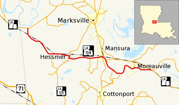
Louisiana Highway 114 (LA 114) is a state highway located in Avoyelles Parish that runs 20.9 miles (33.6 km) in a west–east direction from LA 1 between Echo and Fifth Ward to a second junction with LA 1 and LA 451 east of Moreauville.
Contents
Map of LA-114, Louisiana, USA
LA 114 provides a slightly more direct route than the section of LA 1 it parallels, starting from a point about 20 miles (32 km) southeast of Alexandria, bypassing the city of Marksville to the south, but traveling through the smaller towns of Hessmer and Mansura. Through traffic southeast of Mansura is directed from LA 114 onto LA 1186, connecting to LA 1 northwest of Moreauville, leading through Simmesport and eventually into the Baton Rouge metropolitan area.
Route description
From the west, LA 114 begins at an intersection with LA 1 in western Avoyelles Parish. From this point, located 1.6 miles (2.6 km) east of Echo and 2.8 miles (4.5 km) southwest of Fifth Ward, LA 114 proceeds due south to the Kansas City Southern Railway (KCS) crossing where it curves to the southeast, running parallel with the tracks through Belle d'Eau and across Bayou Choctaw in close proximity to the Grand Cote National Wildlife Refuge. After 4.0 miles (6.4 km), LA 114 turns to the east and intersects LA 1188, which connects to LA 115 south of Hessmer. LA 114 proceeds east, now known as Belledeau Road, and enters the village of Hessmer where the local name changes to West School Street. LA 114 intersects LA 115 (Main Street), which heads north to Marksville and south to Bunkie (via LA 29). LA 114 turns south, running briefly concurrent with LA 115, before resuming an eastward course toward Mansura. After 2.8 miles (4.5 km), LA 114 intersects LA 1187, which runs south and makes a loop back to LA 114. At the second intersection with LA 1187, LA 114 enters the town of Mansura and becomes known as Baton Rouge Avenue.
In Mansura, LA 114 intersects LA 107 (Valley Street), and the two highways travel east in a concurrency for one block along Baton Rouge Avenue to Leglise Street. Here LA 115 turns north toward Marksville while LA 114 turns to the southeast, intersecting LA 1186 at the southern limit of Mansura. LA 1186 heads east, providing a connection to LA 1 that largely bypasses Moreauville. After 1.6 miles (2.6 km), LA 114 intersects LA 1185 at a sharp bend in Bayou Des Glaises. Soon afterward, LA 114 crosses the bayou and intersects LA 29. Both it and LA 1185 head southwest to Cottonport with the former continuing through Evergreen to Bunkie, connecting with US 71. After the intersection with LA 29, LA 114 cuts across a small bend in Bayou Des Glaises then rejoins the bayou, curving northward alongside it into Moreauville. Now known as Bayou Des Glaises Street, LA 114 curves to the southeast with the bayou and then back to the north where it immediately intersects LA 451, which continues northward across LA 1. Meanwhile, LA 114 turns east and travels through town on Main Street. 0.9 miles (1.4 km) past the town limit, LA 114 reaches its eastern terminus at a second intersection with both LA 1 and LA 451, essentially cutting across a massive bend in Bayou Des Glaises. From this intersection, located at a point known as Hamburg, LA 1 heads north toward Marksville and south through Simmesport toward Baton Rouge.
LA 114 is an undivided, two-lane highway for its entire length.
History
In the original Louisiana Highway system in use between 1921 and 1955, the modern LA 114 made up parts of several routes, including State Route 72 from the western terminus near Echo to Mansura; State Route 299 from Mansura to the modern junction with LA 29 west of Moreauville; and State Route 30 from there to the eastern terminus at Hamburg.
LA 114 was created with the 1955 Louisiana Highway renumbering, and its route has remained the same except for an extension on its eastern end over a former alignment of LA 1. LA 114 originally extended east only as far as LA 107 in Mansura. At the time, LA 1 entered Mansura from the north co-signed with LA 107 and proceeded along what is now LA 114 through Moreauville to Hamburg. Around 1964, LA 1 was moved onto a new, straighter alignment along the south side of the Kansas City Southern railroad tracks from Simmesport to LA 1186 east of Mansura, bypassing the Moreauville town center. With LA 114 extended to cover the old route, LA 1 then followed LA 1186 into Mansura, where it was co-signed with LA 114 to the junction with LA 107, and continued to Marksville co-signed with LA 107 as before. The new alignment of LA 1 was extended from LA 1186 north to Marksville in the early 1970s, eliminating the concurrency with both LA 107 and LA 114 in Mansura.
Major intersections
The entire highway is in Avoyelles Parish.