
Country United States Highest elevation > 350 ft (> 106 m) Area 10,868 km² | State(s) Louisiana Lowest elevation 10 ft (3 m) | |
 | ||
Other cities - Baker - Zachary - Denham Springs - Gonzales - Central City - Port Allen - Donaldsonville - Walker - Plaquemine - St. Gabriel | ||
The Baton Rouge Metropolitan Statistical Area, as defined by the United States Census Bureau, is a sprawling area surrounding the city of Baton Rouge. As of the 2010 census, the MSA had a population of 802,484, up from 705,973 in 2000.
Contents
- History
- Parishes
- Places with more than 225000 inhabitants
- Places with 10000 to 30000 inhabitants
- Places with 5000 to 10000 inhabitants
- Places with 1000 to 5000 inhabitants
- Places with fewer than 1000 inhabitants
- Combined Statistical Area
- Components
- References
Comprising the northeastern portion of Acadiana and the western edge of the Florida Parishes regions, it is known as "Plantation Country", the "Capital Region", and "The 225" (a reference to its area code).
Baton Rouge is unusual because it has no major incorporated satellite cities, a rarity for a metropolitan area of its size.
History
The Baton Rouge metropolitan area was first defined in 1950. Then known as the Baton Rouge Standard Metropolitan Area (or Baton Rouge SMA), it consisted of a single parish – East Baton Rouge – and had a population of 158,236. Following a term change by the Bureau of the Budget (present-day Office of Management and Budget) in 1959, the Baton Rouge SMA became the Baton Rouge Standard Metropolitan Statistical Area (or Baton Rouge SMSA). By the census of 1960, the population had grown to 230,058, a 45% increase over the previous census. A total of 285,167 people lived in East Baton Rouge Parish in 1970.
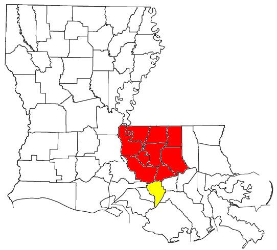
Three additional parishes were added to the Baton Rouge SMSA in 1973 – Ascension, Livingston, and West Baton Rouge. These four parishes had a combined population of 375,628 in 1970. The area grew rapidly during the 1970s and by the 1980 census, the population had increased 32% to 494,151. In 1983, the official name was shortened to the Baton Rouge Metropolitan Statistical Area (or Baton Rouge MSA), which is still in use to date. 528,264 residents lived in the metropolitan statistical area in 1990 and 602,894 people lived in the four parishes by the year 2000.
In 2003, the Baton Rouge MSA was expanded to its current size with the addition of five more parishes – East Feliciana, Iberville, Pointe Coupee, St. Helena, and West Feliciana. This nine-parish region had a population of 705,973 in 2000.
Parishes
Places with more than 225,000 inhabitants
Places with 10,000 to 30,000 inhabitants
Places with 5,000 to 10,000 inhabitants
Places with 1,000 to 5,000 inhabitants
Places with fewer than 1,000 inhabitants
Combined Statistical Area
The Baton Rouge–Pierre Part Combined Statistical Area (CSA) is made up of ten parishes. The statistical area includes one metropolitan area and one micropolitan area. As of the 2000 Census, the CSA had a population of 729,361 (though a July 1, 2009 estimate placed the population at 809,821).