
 | ||
Similar Los Peñasquitos Canyon P, Torrey Pines State Beach, Torrey Pines State Natural R, Batiquitos Lagoon, San Elijo Lagoon | ||
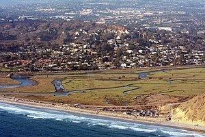
Los pe asquitos lagoon
Los Peñasquitos Marsh Natural Preserve and Lagoon is a coastal marsh in San Diego County, California, United States situated at the northern edge of the City of San Diego, forming the natural border with Del Mar, California. The lagoon, previously called The Soledad Lagoon, divides a colony of the endangered Pinus torreyana on a narrow coastal strip. The name "Los Peñasquitos" is Spanish for "The Little Cliffs".
Contents
- Los pe asquitos lagoon
- Map of Los Penasquitos Lagoon San Diego CA 92121 USA
- Human impact
- Railroad causeway
- Highway 101
- Sewage treatment effluent
- North Beach Parking Lot
- Sediment deposition
- California State Parks
- Los Peasquitos Lagoon Enhancement Plan
- New bridge over lagoon mouth
- Pump Station 64
- Pump Station 65
- Closure of Sorrento Valley Road
- West Nile Virus
- Tick diseases
- Rattlesnakes
- Mountain Lions
- Trails
- Marsh Trail
- Closed section of Sorrento Valley Road
- Del Mar trail unnamed
- SR 56 Bike Route
- References
Map of Los Penasquitos Lagoon, San Diego, CA 92121, USA
Human impact
For many years, the Los Peñasquitos Lagoon had evolved from a tidal estuary to a lagoon that was closed to tidal action for long periods of time. Since becoming a part of the State Park System, there have been a number of changes that have increased the tidal action within the lagoon.
Railroad causeway
In 1925, the Santa Fe Railroad built a single-track roadbed causeway embankment down the center of the lagoon for its Surf Line, which still is in use today on a daily basis by the San Diego Coaster and Pacific Surfliner as well as BNSF freight trains. This embankment severely restricted the normal historical lagoon drainage for the first time, and changed the tidal flow and current pattern. The original bridges are slated to be replaced in 2015-2017, and additional plans for a double-tracking solution through the lagoon appear to be slated for the 2040-2050 timeframe.
Highway 101
When the Pacific Coast Highway (U.S. Route 101 in California) was expanded in the 1930s, the roadbed along the beach was heightened, and a bridge was built over the mouth the lagoon. This bridge had many wooden pilings that easily got clogged with sand and debris, impacting the water transfer between the ocean and lagoon.
Sewage treatment effluent
Over the years, at least three different waste water treatment plants have pumped their treating effluent into the lagoon. The Callan Treatment plant pumped 50,000 US gallons (190,000 L) per day during the 1950s; the Sorrento plant produced 500,000 US gallons (1,900,000 L) per day starting in 1962; and the Pomerado Waste Water Treatment Plant pumped treated sewage into the lagoon from 1962 to 1972.
North Beach Parking Lot
The triangular North Beach Parking Lot was built in 1968. It is accessible via Carmel Valley Road at McGonigle Road / Del Mar Scenic Parkway, and is bounded on three sides by the arch bridge at North Torrey Pines Road, the railroad causeway, and the lagoon's ocean inlet. Previous to the State Park, there had been a number of tourist beach houses in the area, called Sunken City, that had been moved from the open beach during the 1932 construction of the large causeway for North Torrey Pines Bridge.
According to LPL Foundation and the State Coastal Conservancy, this fully paved parking lot significantly altered the lagoon’s hydrology.
Sediment deposition
Due to the high rate of sediment deposition that surpasses the federally-mandated total maximum daily load, Los Peñasquitos Lagoon is listed as a category 5 impaired body of water under section 303(d) of the Clean Water Act. This is primarily due to the adverse effects of sedimentation in the lagoon itself and also within its vast watershed. These effects include drops in photosynthetic productivity, higher concentrations of heavy metals, and overall loss of ecosystem biodiversity within the estuary. In addition to ecological impacts, sedimentation in the Los Peñasquitos watershed has led to significant issues within its storm water infrastructure. Specifically, sediment accumulation in flood control channels has greatly reduced original storm water conveyance capacity. This is primarily due to the vegetation that grows within the channels as a result of siltation. Regular maintenance of these channels by the Storm Water Division is therefore a necessity to ensure proper flood control. Despite the need for sufficient flood control through regular channel maintenance, the extensive permitting process involved requires selection and planning that extends nearly two years before any service activities.
California State Parks
The California Division of Parks and Recreation has designated the status of Los Peñasquitos Lagoon as a State Preserve, which has much more restricted access than the State Park designation. There is very limited public use of Los Peñasquitos Marsh Natural Preserve, with most of the area signed as "Do Not Enter". The California State Preserve status is granted to only the rarest and most fragile of the state owned lands.
The State Preserve covers the saltwater lagoon area of over 630 acres (2.5 km2) adjacent to Torrey Pines State Beach and Torrey Pines State Reserve. An additional 240 acres (0.97 km2) of marshland was added to this California State Parkland in 1987, when it was purchased from SDG&E for $2.25 million. SDG&E has originally purchased the land in 1966 as a possible site for a new nuclear power plant that was never built.
Los Peñasquitos Lagoon Enhancement Plan
In 1985, the California Coastal Conservancy created the Los Peñasquitos Lagoon Enhancement Plan to deal with a number of human-caused problems. A lagoon management program is now in place to monitor water quality, manage the manual removal of sand and debris upon lagoon mouth closures, give oversight and recommendations for improved usage, and coordinate with other agencies to protect and restore the lagoon. The Los Peñasquitos Lagoon Foundation, formed in 1983, is 501 3(c) non-profit and is the management entity charged with implementing the enhancement plan in coordination with State Parks and the State Coastal Conservancy. More information on Los Peñasquitos Lagoon and its watershed, the Los Peñasquitos Lagoon Foundation (LPLF) and resource management within the lagoon and its watershed can be found at the following website: lospenasquitos.org
New bridge over lagoon mouth
In 2005 a new bridge was built over the mouth of the lagoon, greatly enhancing the free-flowing transfer of the tidal currents. The new bridge replaced the existing bridge's 72 pilings with just four that support a much longer span across a larger mouth opening. This should greatly reduce the number of times the lagoon mouth closes completely, thus saving the costs of mechanical removal of sand by large earth-moving equipment.
This new bridge is sometimes called North Torrey Pines Bridge, although that same name is sometimes applied to the taller arch bridge immediately to its north. This lower bridge over the lagoon inlet was built by Flatiron and cost $9,628,750.
Pump Station 64
The City of San Diego's waste water treatment and pumping stations have been improved and replaced over the years so that they do not pump treated effluent directly into the lagoon any more. Pump Station 64 is located in an industrial area at the very far upstream end of the lagoon, near the Sorrento Valley Coaster Station. Pump Station 64 has often malfunctioned and spilled millions of gallons of raw sewage directly into Los Penasquitos Lagoon, in fact between 1977 and 1986 there were 60 such spills. There were a number of improvements and fixes made, with a new $23 million facility being completed in 1988. This helped considerably in keeping the lagoon much cleaner once the new station came on-line, however there are still spills, with the most recent being on September 9, 2011 when an estimated 1.9 million US gallons (7,200 m3) of raw sewage was released due to a county-wide power outage.
Pump Station 64 is located at 10745 Roselle Street, San Diego, California, just east of Interstate 5.
Pump Station 65
Pump Station 65 was rebuilt and relocated in 1996 to sit on the edge of the lagoon next to a now-closed portion of Sorrento Valley Road. Pump Station 65 is a modern building, and pumps an estimated 19 million US gallons (72,000 m3) per day south to Pump Station 64. The sewage lines and pumping station located in the lagoon area are slated for retirement. Pump Station 65 is planned to be relocated out of Los Peñasquitos Lagoon along with associated relocation and upgrading of major trunk sewers.
Pump Station 65 is located at 12112 Sorrento Valley Road, San Diego, California.
Closure of Sorrento Valley Road
In 1996, the northernmost portion of Sorrento Valley Road skirting the very edge of the lagoon between Carmel Valley Road and Carmel Mountain Road was closed in order to build Pump Station 65. The road remained closed during the Interstate 5/805/56 interchange improvements, and on February 25, 2003, the San Diego City Council voted to permanently close it and convert the corridor to a bike path/multi-use trail. Closing the road has improved access to a wildlife corridor for deer, fox, coyote, bobcat and spotted skunk to enter and exit the Preserve.
West Nile Virus
Los Peñasquitos Lagoon is one of the known breeding grounds in California of mosquitoes infected with the West Nile virus (WNV), a virus that originated in Uganda and arrived in California in 2003. The number of yearly incidents of WNV infection in San Diego County has been rising since 2008. The virus is often fatal to birds, which is the primary animal affected, but horses and humans have also died from it. One in five infected humans will show flu-like symptoms, and will sometimes require hospitalization for meningitis. In 2009 one boy developed flu-like symptoms and became delirious a few days after having had a picnic near Los Peñasquitos Lagoon, and needed to be hospitalized for WNV infection, presumably acquired by mosquito bite. Pickup trucks can sometimes be seen around the lagoon spraying for mosquitoes to prevent the spread of WNV.
Tick diseases
Deer are found in the marsh area, such as along closed Sorrento Valley Road, and often carry ticks that are left behind on vegetation that can brush against hikers, whereupon the ticks are often inadvertently transferred to hikers. Ticks can carry Lyme disease or Tularemia (rabbit fever). Lyme disease, if left untreated, can cause heart and brain disorders, including paraplegia in severe cases, and Tularemia can lead to incapacitating fever and in rare cases death. The canyon on the west side of Interstate 5 between Genesee Avenue and Sorrento Valley Road is particularly abundant with ticks, and a sign on the Del Mar trail near Carmel Valley Road warns hikers that ticks are found along that trail. Fortunately, Lyme disease happens to be "quite rare" in San Diego County, unlike most other counties in California, and Lyme disease is usually treatable, especially if detected early.
Rattlesnakes
Rattlesnakes are found throughout San Diego County, and a warning sign along the Marsh Trail reminds hikers that rattlesnakes are also found in the marsh area.
Mountain Lions
Although mountain lions (Felis concolor) are now rare in the Torrey Pines and Los Peñasquitos Lagoon area, likely as a result of habitat fragmentation, mountain lion tracks and scat were reported between Interstate 5's bridge and Los Peñasquitos Lagoon in 2000 by the Conservation Biology Institute in Encinitas. Mountain lions are relatively common in Los Peñasquitos Canyon Preserve , which is only a few miles away and connected to Los Peñasquitos Lagoon by Los Peñasquitos Creek. Mountain lion attacks have occurred on dogs and humans in San Diego County, and have sometimes resulted in human fatalities.
Trails
Although public access is forbidden in the central parts of the lagoon and marsh, there are about four trails that are near the marsh area that do not explicitly bar public use.
Marsh Trail
The official name of this trail is simply Marsh Trail. It is unpaved on its west end and paved on its east end. It is shown on Google maps. Dogs and bicycles are prohibited. It skirts the southern edge of the wetland for 1.5 miles from North Torrey Pines Road and becomes Flintkote Avenue in Sorrento Valley, San Diego. The trailhead is across from the South Beach parking lot at Torrey Pines State Beach.
Closed section of Sorrento Valley Road
Paved. Motor vehicles are prohibited, but bicycles and pedestrians are permitted. Bicycles are very common. It skirts the eastern edge of the wetland from near the Park & Ride parking lot to near Pump Station 65. Both ends outside of the closed section are regularly used by motor vehicles.
Del Mar trail (unnamed)
Unpaved. Dogs are prohibited. Both trailheads are on Carmel Valley Road, one at the corner of McGonigle Road, and the other immediately west of Del Mar Car Service. The trail is relatively short, in a fairly dry area, and roughly follows the railroad causeway.
SR-56 Bike Route
Paved. It is shown on Google maps as "56 Bike Trail". This lies on the east side of Interstate 5. It follows Carmel Creek and California State Route 56. Bicycles, horses, and pedestrians are permitted, but not motor vehicles. Bicycles are very common.