
Highest point The Cabox Country Canada | Elevation 814 m | |
 | ||
Mountains Gros Morne - Newfoundland, The Cabox, Pic a Tenerife, Mount Musgrave Similar Bonne Bay, Gros Morne - Newfoundland, The Cabox, Lobster Cove Head Lighthouse, Blow Me Down Provincial | ||
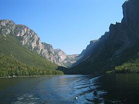
Fog rolling over long range mountains in lark harbour newfoundland
The Long Range Mountains are a series of mountains along the west coast of the Canadian island of Newfoundland. They also form the northernmost section of the Appalachian chain on the eastern seaboard of North America. In 2003 it was announced that the International Appalachian Trail would be extended through the Long Range Mountains.
Contents
- Fog rolling over long range mountains in lark harbour newfoundland
- Map of Long Range Mountains Division No 9 Subd H NL Canada
- The long range mountains
- References
Map of Long Range Mountains, Division No. 9, Subd. H, NL, Canada
During the Precambrian, around 1,200 million years ago, the ancient core of what is now eastern North America collided slowly with another continent to form a vast mountain range. All that remains today are the deeply eroded granites and gneisses of the Long Range mountains.
In the Precambrian, the supercontinent began to break apart. As it split, steep fractures formed and filled with molten rock from below. This magma cooled into the diabase dykes seen in the cliffs of Western Brook Pond and Ten Mile Pond.
By 570 million years ago the continent finally rifted apart, and the resulting basin became an ocean called the Iapetus Ocean. Some of the rocks of Gros Morne National Park were part of the continental margin on the western side of this new ocean, south of the Equator.
Running along the Gulf of St. Lawrence, the range includes the following sections: