
 | ||
Lone Rock Point is an promontory north of Burlington, Vermont and on the eastern shore of Lake Champlain. It is publicly accessible via a trail network and sits on land owned by the Episcopal Diocese of Vermont.
Contents
- Map of Lone Rock Point Burlington VT 05408 USA
- Dunham Formation at Lone Rock Point
- Iberville Shale at Lone Rock Point
- References
Map of Lone Rock Point, Burlington, VT 05408, USA
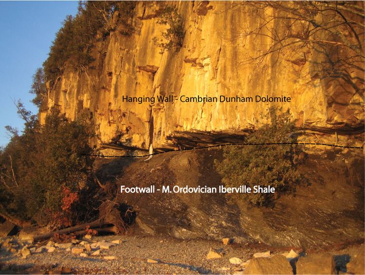
The site is of geologic significance for its spectacular exposure of a thrust contact between the Cambrian-aged Dunham Dolostone and the Middle-Ordovician Iberville Shale. The thrust fault exposed at this location is regionally called the Champlain Thrust which formed during the Taconic Orogeny. At this site, the stratigraphic throw of the Champlain Thrust measures about 8,850 feet.
The site is arguably the most visited structural geology feature in all of New England and is featured in many structural geology text books as a classic example of a thrust fault.
Dunham Formation at Lone Rock Point
The Dunham Formation is a Cambrian dolostone that is exposed in the hanging wall of the Champlain Thrust Fault at Lone Rock Point. This unit was initially deposited in a warm, shallow sea environment as a platform carbonate. Well-exposed mullions at the base of the dolomite plunge about 15 degrees southeast, indicating transport direction (headed toward the modern lake.) The light colored rocks along the shoreline are dolostones that have fallen after the shale eroded away.
Iberville Shale at Lone Rock Point
The Ordovician Iberville Shale was likely deposited in a deeper marine environment and consists of fine-grained clastic materials.[1] Slip surfaces within the Iberville Shale seen at Lone Rock Point often contains calcite slickenlines along the planar thrust surface. Overlying pressure has led to a high degree of vertical faulting and calcite dissolution (white banding) throughout the unit. The top-most layer of the shale has been eroded away.