
Population 9,486 (2011) Sovereign state United Kingdom Local time Thursday 11:53 AM | OS grid reference SS975685 Country Wales Post town LLANTWIT MAJOR Dialling code 01446 | |
 | ||
Weather 8°C, Wind NE at 37 km/h, 80% Humidity | ||
A visit to st illtuds church llantwit major south wales
Llantwit Major (Welsh: Llanilltud Fawr) is a small coastal town and community in the Vale of Glamorgan, Wales, on the Bristol Channel coast. It is one of four towns in the Vale of Glamorgan and the third largest by population (13,366 in 2001) after Barry and Penarth, and ahead of Cowbridge, which lies about 4.5 miles (7 km) to the north-east. The town centre of Llantwit Major lies about 9 miles (14 km) south-east of the centre of Bridgend, 10 miles (16 km) west of the centre of Barry, and about 15 miles (24 km) miles south-west of the centre of the Welsh capital of Cardiff.
Contents
- A visit to st illtuds church llantwit major south wales
- Map of Llantwit Major UK
- Name
- History
- Geography
- Economy and local government
- Roman villa
- St Illtyds Church and monastery
- Town Hall
- Great House
- Dove cote and gatehouse
- The Old Place
- Old Swan Inn
- The Old White Hart Inn
- Plymouth House
- Court House
- Knolles Place
- Old police station
- War memorial
- Bethel Baptist Church
- Boverton Place
- Dimlands
- Hillhead
- Education and sport
- Notable people
- References
Map of Llantwit Major, UK
The town's name in Welsh, Llanilltud Fawr, is derived from the name of Saint Illtud, who came to the area from Brittany, Gaul. He founded the monastery of Illtud and the college attached to it, Cor Tewdws, which would grow into one of the most esteemed Christian colleges of the times. At its peak it attracted over 2000 students, including princes and numerous eminent clergymen, some now revered as saints. Destroyed by the Vikings in 987, the monastery was rebuilt in 1111 and continued to be a centre of learning governed by Tewkesbury Abbey until it closed in 1539 during the Dissolution of the Monasteries. The 13th-century St Illtyd's Church, built near the ancient monastery, is today a Grade I listed building and one of the oldest parish churches in Wales.
The modern town of Llantwit developed rapidly in the 20th century to accommodate Royal Air Force personnel from the base at nearby St Athan, but it retains its medieval cobbled streets and buildings of the 15th and 16th centuries. Llantwit Major railway station on the Vale of Glamorgan Line reopened in June 2005. Collugh Beach is a popular surfing venue and has the remnants of an Iron Age fort and some of the finest examples of Jurassic Period fossils in Wales. The pebble beach and its dramatic clifftops are part of a 14 miles (23 km) long coastline protected under the Glamorgan Heritage Coast, which stretches from Gileston in the east to Newton Point beyond Southerndown in the west.
Name
Although the parish church glosses the name of the town rather literally as "Illtud's Great Church", neither the Welsh placename nor its English form properly call the place "great", but rather "greater": the epithet fawr distinguishes this Llantwit from Llantwit Fardre (Llanilltud Faerdref) near Pontypridd and Llantwit Minor (Llanilltud Fach; also known as Llantwit-juxta-Neath and Lower Llantwit) near Neath. The Welsh placename element llan referred to the sanctified community around early Christian settlements in Wales and its parish rather than merely the church itself (eglwys).
History
Llantwit Major has been inhabited for over 3000 years: archaeological evidence has shown that it was occupied in Neolithic times. in the beach area are the remains of an Iron Age fort. Excavations at the Roman villa at Caer Mead have revealed that this area was inhabited for around 350 years during Roman times; its bathrooms and the mosaic pavements date from the mid 2nd century AD.
In the 5th century, after the withdrawal of the Roman legions, Saint Illtud came to the Hodnant valley from Brittany and founded the monastery of Illtud on the Ogney Brook, and a college, close to the current St Illtyd's Church, about a mile from the sea. The exact date of its founding is unknown, but some sources indicate around the year 500; the blue plaque on the church today also gives this date. Because of its monastery and teaching centre it became a major centre for education and Celtic Church evangelism, attracting scholars from across Wales, Devon, Cornwall and Brittany and the wider world. The college of Llantwit, known as the College or Seminary of Theodosius (Cor Tewdws in Welsh) or College of St. Illtyd, at its peak reputedly had seven halls, over 400 houses and over 2000 students, including seven sons of British princes, and scholars such as St. Patrick, St. Paul Aurelian, the bard Taliesin, Gildas the historian, Samson of Dol, Paulinus, Bishop of Leon; St. David is believed to have spent some time there. Samson was known to have been summoned by Dyfrig to join the monastery in 521 and he was briefly elected abbot before leaving for Cornwall. King Hywel ap Rhys (d. 886) was buried at the monastery.
The college suffered during the invasions of the Saxons and the Danes and was destroyed by the Vikings in 987 and again by the Normans in the late 11th century. However, in 1111, it is documented as being restored, but likely in a lesser state than the original. It is known to have continued to function as a monastic school until the 16th-century Reformation. The ruins of the original school house are located in a garden on the northern end of the churchyard and the monastic halls were located in a place called Hill-head on the north side of the tithe-barn. Although nothing of the original monastery remains, the present church was originally built between 950 and 1400 and its earliest existing secular buildings date from the 15th century. The church and school became the property of Tewkesbury Abbey around 1130 after becoming part of the Norman kingdom of Glamorgan.
After the dissolution of the monasteries by king Henry VIII during the Reformation, it became independent from Tewkesbury in 1539. St Donat's Castle, 1.5 miles (2.4 km) to the west, was built in the 13th century.
In the 20th century, Llantwit developed into a dormitory town and grew about 15 times in size to accommodate the Royal Air Force at St Athan. Despite its modernization and rapid growth, it retains its pre-modern feel with its narrow winding streets, high walls, old town hall and gatehouse, and several inns and houses dated to the 16th century. Llantwit Major railway station on the Vale of Glamorgan Line was reopened in June 2005. In 2014, it was rated one of the most attractive postcode areas to live in Wales.
Geography
Llantwit Major is located in southeast Wales and mid-west along the coast of the Vale of Glamorgan. The town can be accessed from the north directly by the B4268 road and indirectly by the B4270 road (St. Athan road) which branches from the A48 road, and directly by the B4265 road which leads to Bridgend in the northwest and Cardiff Airport and Barry in the east. It is one of four towns in the Vale of Glamorgan and the third largest by population after Barry and Penarth, and ahead of Cowbridge, which lies about 4.5 miles (7 km) to the northeast. The town centre of Llantwit Major lies about 9 miles (14 km) from the centre of Bridgend, 10 miles from the centre of Barry and about 15 miles (24 km) from the centre of Cardiff which lies further to the east. Boverton is an eastern suburb of Llantwit.
A small stream, the River Ogney, runs through the town and joins the streams [Hoddnant and Boverton Brook] which flow in from Eglwys Brewis in the north-east; these then merge and become the Afon Colhuw, which meanders down the Colhuw meadows before discharging through an outfall into the sea. The Llantwit Major area is built on a range of different levels and the town itself is sloping. At the lower coastal level is the flat, glacial Collugh Valley, marked by steep cliffs on both sides, leading to a pebble beach. The beach, located to the south of the town (51.396667°N 3.500833°W / 51.396667; -3.500833), has the remains of an ancient old stone wall from the large Iron Age hill fort, Castle Ditches. The steep cliffs at Llantwit which allow walks along the coast to St Donat's Castle and Atlantic College have undergone dramatic erosion in recent years: in many places, the rock structure has collapsed in piles, particularly on the eastern face.
The cliff path, once set about 100 yards (90 m) from the edge is now within metres of the nature pathway, and the Vale of Glamorgan Council has installed extensive new barriers to prevent fatalities. The 14 miles (23 km) of coastline from Gileston in the east to Newton Point in the west, passing through St Donat's and Southerndown, is protected as part of the Glamorgan Heritage Coast. Tresilian Bay is between Llantwit Major and St Donat's. Along this stretch of coast the cliff path winds through numerous valleys. Llantwit Major beach has one of the finest sites in Wales for Jurassic fossils, including corals, giant brachiopods, gastropods and the bones of Ichthyosaurus.
In the early 1990s the beach flooded: the tide rose beyond the beach wall and inundated the surrounding pasture in the valley, which is now used as a campsite.
The beach is popular with summer tourists, and has a campsite on the nearby fields. The beach has a snack bar and restaurant and associated amenities to cater for the increased public demand in recent years. There is an expansive rocky beach at low tide, with a stretch of sand towards the far west, and views of the Bristol Channel and the coastline of Somerset, with the landmark white roof of Butlins, Minehead.
Economy and local government
Llantwit Major is a small town which is largely dependent on local retail and earnings from further afield. The majority of the inhabitants commute to work elsewhere, especially Cardiff or Bridgend. During the summer months tourism is important to the town which has "The Precinct", Rainbow Plaza and several pubs and restaurants. Of note are the Old Swan Inn, Old White Hart Inn, The Tudor Tavern, and the 17th century West House Country Hotel Heritage Restaurant.
Llantwit Major has considerable renown in South Wales as a surfing location, although it is much less known than Porthcawl further down the coast. The beach has a lifeguard station funded by the Vale of Glamorgan Council, built in the late 1990s, functioning during the summer months. There is a surf shop in the town catering to surfers and several others selling items related to surfing fashion. Parking is free. THere is a beach cafe and often organised walks.
The Victorian Fair Day, established in 1983, is usually held in June on the Saturday nearest to the 22nd of the month, with a Victorian theme which attracts people from across southern Wales. The town has several supermarkets including Somerfield and Filco, and a town library. At least three pharmacies and two banks (HSBC and Lloyds TSB) located in the central shopping area along Boverton Road. The local artistic community supports a number of arts and crafts shops, some selling locally made pottery and other ceramics.
An electoral ward of the same name exists. This ward covers Llantwit Major community but also stretches west to St. Donats. The total population of this ward at the 2011 census was 10,621.
The town is governed by the Llantwit Major town council consisting of fifteen councillors. There are fifteen independent councillors . The current Mayor is Councillor Mick Mason. It also comes under the administration of the Vale of Glamorgan unitary authority. Llantwit Major is twinned with Le Pouliguen, France.
Roman villa
The Roman villa at Caermead (51.4192°N 3.4989°W / 51.4192; -3.4989) remains as faint earthworks in a field, near the 13th century parish church of St Illtud. The L-shaped courtyard villa was discovered in 1888. Records from 1893 suggest that one room was used as a praetorium, another as a workshop; and there was a 5th-century adjoining sacristy, simple in style, which featured a chancel, nave, and stone altar. Found remains included Brachycephalic and dolichocephalic skulls, as well as horse bones. Fine mosaic floors are a notable feature of the villa. The tesserae included blue and crystalline limestone, green volcanic stones, brown sandstone, and red-brick cuttings, encircled with a red, white, blue and brown border. A record from 1907 described the relics as Samian ware pieces; bronze coins of Maximinus Thrax, Victorinus, and Constantius Chlorus; as well as roofing materials.
The site was again excavated between 1938 and 1948. It may have been first settled in the 1st century, but the first stone structure was not erected until a hundred years later. The site developed slowly and, it has been suggested, was even abandoned for a while during the 3rd century. By the 4th century, there was an L-shaped villa with a large, aisled building possibly for farm workers and a number of smaller agricultural structures almost enclosing a central courtyard. The Royal Commission on the Ancient and Historical Monuments of Wales has associated collection records of the site, including drawings of other remains such as statues and tessellated pavement, as well as documentation of a 1971 excavation. An early-medieval-period cemetery is in evidence. as are earthworks, traces of walling, a bank and a ditch. Pieces of pottery have been found.
St Illtyd's Church and monastery
The town grew up around Cor Tewdws, a monastery and divinity school, alternately named Caerworgorn, or Bangor Tewdws (College of Theodosius), or later Bangor Illtyd ("Illtyd's college"). Saint David, Saint Samson, Saint Paul Aurelian, Saint Gildas, Saint Tudwal, Saint Baglan and king Maelgwn Gwynedd are said to have studied at the divinity school.Cor Tewdws was destroyed in AD 446 and re-founded in AD 508 by St Illtyd as a centre of learning. The ruins of the school are in a garden on the north side of the churchyard; and the monastery was situated north of the tithe barn on Hill Head.
The elongated church (51.4081°N 3.4878°W / 51.4081; -3.4878), a conglomeration of distinct buildings, is divided into two areas by a wall, a 13th-century monastery church, and the Norman parish church. The eastern section contains interesting medieval wall paintings with religious themes, and a fine reredos. The western section, a Lady chapel, 40.5 feet (12.3 m) in length, has an inscription to King Rhys ap Arthfael of Morgannwg who died in the mid-9th century. The church contains a curfew bell and medieval priest effigies. The older church is 64 feet (20 m) long; the newer church was built by Richard Neville.
St. Illtyd's church predates the Age of the Saints in early Welsh Christianity and thus by its very existence provides evidence of continuity with sub-Roman Christianity. The churchyard contains three ancient relics, a pillar and two inscribed stones; one dates from Saint Samson's time. The grounds also include a 13th-century gatehouse, a monks' pigeon-house, ruined walls in a garden area, and mounds near the vicarage.
Town Hall
Manorial records indicate that the Town Hall (51.4076°N 3.4848°W / 51.4076; -3.4848) dates to the 15th century but it is often attributed to Gilbert de Clare, Lord of Glamorgan, who died much earlier in 1295. It then functioned as a manor and a meeting venue for the court to organise duties and collect rents and at weekends held fairs. It was renovated in the late 16th century and over the years the lower floor functioned as a school, a slaughterhouse and a jail and the top floor a venue for church meetings, leased to Oddfellows in the 1830s. Aside from fairs it also held plays, concerts and dances. It became a Grade: II* listed building on 22 February 1963. It features a bell with the inscription, Sancte Iltute, ora pro nobis ("Saint Illtyd, pray for us"). It is reached by a flight of steps.
Great House
The Great House (51.412361°N 3.488173°W / 51.412361; -3.488173), located along the road to Cowbridge, on the northern outskirts originally dated from the 14th century when it consisted of just a square central section, but significant additions have made it an excellent example of a Tudor "Ty mawr" (Great House). A northern wing with a stable and dovecot were amongst the added parts. The house was occupied by the Nicholl family for centuries but by the 1920s it had been abandoned and fell into a heavily dilapidated state. The building was bought and restored to its former glory in the 1950s.
Dove cote and gatehouse
Covered by a domical vault, the Dove Cote (51.406414°N 3.48913°W / 51.406414; -3.48913) is a Grade II* listed tall 13th-century cylindrical column in a middle of the Hill Head field, which lies in close proximity to St Illtuds Church, next to the site of the old tithe barn, built for the monks at the St. Illtud's monastery. Another site on Hill Head is the (13th–14th century) gatehouse, now belonging to St Illtyd's Church, Llantwit Major. Today these are the only remaining buildings which at one time belonged to Tewkesbury Abbey. There is a plaque on the gatehouse, telling of its history.
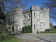
The Old Place
The Old Place (51.407665°N 3.489745°W / 51.407665; -3.489745) is a ruin of an Elizabethan manor house, built by Griffith Williams for his daughter and son-in-law Edmund Vann in 1596. It is often mistakenly called Llantwit Castle. The Williams family were successful lawyers and part of the rising minor gentry who were loathed by the Seys of Boverton and the Stradlings of St Donats. Vann was fined over £1,000 for being involved in a scuffle in central Llantwit on a Sunday which led him to take on the Sey family and seek his revenge.
Old Swan Inn
Records state that a building was located here from the 11th century and during medieval times it is believed to have been a monastic or manorial mint. but the current Grade II* listed inn (51.408341°N 3.486029°W / 51.408341; -3.486029) is dated to the 16th century, aside from restoration work; it was once thatched roofed. It was run for many years in Tudor times by the Raglan family. In the mid 17th century there is evidence that its owner Edward Craddock was again using it as a mint to "mint his own tokens as there was a shortage of coin at this time." There are five other pubs and four restaurants in the town.
The Old White Hart Inn
The Old White Hart Inn is Grade II listed, and described as a late 16th century building. The building was an end entry house but it is unclear when it became an inn. It has been suspected that the building was previously used as a courthouse, but this has never been proved. Moreover, tokens were given out under the Old White Hart's name in the 18th century.
Plymouth House
According to the blue plaque on the wall outside Plymouth House (51.408791°N 3.488876°W / 51.408791; -3.488876), the house is believed to have been formerly part of the monastery, perhaps functioning as a halled house for some time in the fifteenth century. After its closure in 1539, it became the manor house of West Llantwit owned by Edward Stradling. Later owners include Lewis of the Van, the Earl of Plymouth and then Dr. J. W. Nicholl Carne, who renamed it after its previous owner some time in the 19th century.
Court House
From the blue plaque on the Court House (51.409519°N 3.485348°W / 51.409519; -3.485348), it was formerly known as Ivy house when it was a town house from the 16th century. In the 18th century it was extended by Christopher Bassett. For some time it was owned by the Throckmorton family of Coughton Court, Warwickshire, descendants of one of the perpetrators of the Gunpowder Plot. Later owners included Daniel Durrell, headmaster of Cowbridge Grammar School, and the benefactor of Tabernacle Chapel, Elias Bassett. It then fell to his niece and her husband William Thomas and became part of the Thomas family and at one time was owned by Illtyd Thomas, father of Mare Treveleyan, an antiquarian. The Thomases built the Town Hall clock to commemorate Queen Victoria.
Knolles Place
According to the blue plaque on the building (also known as "The Old School") (51.408413°N 3.487469°W / 51.408413; -3.487469), it was built around 1450 by John Raglan (Herbert) and was then owned by Robert Raglan, from a family who had significant power in the area at the time and held many local administrative posts as stewards and priests. In the 17th century it became a vicarage for Stephen Slugg and functioned as a boarding school for primary school children between 1874 and 1975.
Old police station
The old police station (51.4069°N 3.4872°W / 51.4069; -3.4872)was built in the mid-1840s after the place is Glamorgan Constabulary was established in 1841, and was originally comprised a single-storey building, but was expanded in 1876 to include four bedrooms on the top floor. It continued to function as a police station until 1928 when a new building opened nearer the town centre on Wesley Street.
War memorial
This is located in the centre of Llantwit War Memorial (51.40842°N 3.486894°W / 51.40842; -3.486894), between the Old Swan and the White Hart and has a Celtic cross. The memorial commemorates residents who lost their lives or went missing in World War I and World War II. There are 32 names listed for World War I and 26 names for World War II.
Bethel Baptist Church
Bethel Baptist Church (51.408714°N 3.485035°W / 51.408714; -3.485035) was erected in 1830 to provide for local Baptists and its first minister was a local shopkeeper named Jabez Lawrence. Christmas Evans, a one-eyed Welsh preacher of considerable renown was reported to have held services here.
Boverton Place
Located in Boverton, Boverton Place (51.404751°N 3.464059°W / 51.404751; -3.464059) is a former fortified manor house, now in ruins. It was built at the end of the 16th century and served as the seat of Roger Seys, Queen’s Attorney to the Council of Wales and the Marches in the 1590s. It remained in Seys family until the last heiress Jane Seys married Robert Jones of Fonmon who sold it to owners who let it fall into ruin. Its last occupants were mentioned in the census of 1861.
Dimlands
Dimlands (or Dimland Castle or Dimland Lodge) (51.406172°N 3.501055°W / 51.406172; -3.501055) is situated about a kilometre back from the clifftops of the Bristol Channel along the road to St. Donats. It was owned at one time by John Whitlock Nicholl Carne of the University of Oxford who moved there after his father's death. Dimlands was built by John Carne's father, Rev. Robert Carne, at the end of the 18th century, upon land left him by his father, Whitlock Nicholl of The Ham, sheriff for the county of Glamorgan in 1746. The property was held by the Nicholl family since the time of King Henry VII. The dwelling is of castellated Tudor architecture with blue lias limestone exterior, and Coombedown stone windows and cornices. The south-facing front is more than 130 feet (40 m) in length. The western coast of Cornwall and Lundy Island are visible from the turrets. The carved chimney in the dining room is made of Caen stone, and the chimney-piece in the drawing room is also. Other features are the Minton tile flooring, the large Tudor-style staircase, two sitting rooms, and the library, a newer addition. The Dimlands stables feature sharp-pointed gables, as well as a carved stone with the date of the original grant (1336).
Hillhead
On the hillside of the Colhugh Valley there are a row of houses situated at Hillhead in Llantwit Major. The houses were built in the early years of the 19th century for the poor of the parish. With the introduction of the Poor Law Amendment Act of 1834, a workhouse was opened in Bridgend. The houses became surplus to requirements and were then sold as private residences. Llantwit Major came under the Bridgend and Cowbridge Poor Law Union. Each unit was originally divided into two separate upper and lower accommodation, the upstairs entrance was from the west and the entrance to the lower accommodation came from the east.
Education and sport
Llanilltud Fawr Comprehensive School is the secondary school in the town. A fire gutted the building in October 1991 and a new building was constructed. The school has roughly 1300 pupils and around 85 full-time staff. Immediately adjacent is Llanilltud Fawr primary school, one of four primary schools in Llantwit, the others being Eagleswell primary school, Ysgol Dewi Sant and St. Illtyd's primary school.
Facilities at the Llantwit Major leisure centre include a small swimming pool, large and small sports halls, the LifeStyle Fitness Studio, sunbed facilities, conference room and bar. The Llantwit Major Rugby Football Club, which played its first match against Cowbridge Rugby Football Club in 1889, fields two senior, one youth (U/19) and eight mini/junior teams, and plays in Division Four of the Welsh Rugby Union leagues. Other sports clubs represent association football and cricket.