
Population 1,311 (2011 Census) Community Llangadog Country Wales Local time Thursday 11:19 AM | OS grid reference SN704285 Sovereign state United Kingdom Dialling code 01550 | |
 | ||
Weather 8°C, Wind NE at 26 km/h, 78% Humidity UK parliament constituency Carmarthen East and Dinefwr | ||
Llangadog is a community located in Carmarthenshire, Wales, which includes the villages of Llangadog, Bethlehem and Capel Gwynfe. A notable local landscape feature is Y Garn Goch with two Iron Age hill forts.
Contents
Map of Llangadog, UK
Llangadog was the administrative centre of the commote of Perfedd and had a castle, destroyed in 1204. Although the borough declined in the Middle Ages, Llangadog retained its market, which was frequented by drovers into the 19th century.
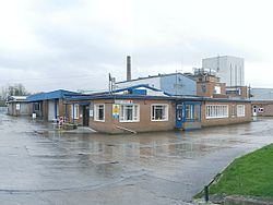
The railway station on the Heart of Wales Line provides regular train services via Arriva Trains Wales. The station had a siding for accessing the Co-op Wholesale Society creamery, allowing milk trains to access the site. After railway access was ceased in the late 1970s, the creamery continued to operate until 2005, when it closed with the loss of 200 jobs. The site has since been redeveloped as a pet food factory.
Governance
An electoral ward with the same name exists. This ward stretches beyond the confines of Llangadog community. The total ward population taken at the 2011 census was 1,929.
The community is bordered by the communities of: Myddfai; Llanddeusant; Quarter Bach; Dyffryn Cennen; Manordeilo and Salem; and Llansadwrn, all being in Carmarthenshire.