
Population 517 (2011) Sovereign state United Kingdom Local time Thursday 11:47 AM | Community Llansadwrn Country Wales Postcode district SA19 8 Dialling code 01550 | |
 | ||
Weather 8°C, Wind NE at 27 km/h, 79% Humidity UK parliament constituency Carmarthen East and Dinefwr | ||
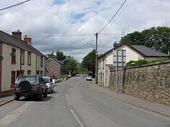
Llansadwrn is a community and small village in Carmarthenshire, Wales.
Map of Llansadwrn, UK
It is located in the countryside of the River Tywi river valley, about half way between Llanymddyfri to the north-east, and Llandeilo to the south-west, just off the A40 road. The community is bordered by the communities of: Cynwyl Gaeo; Llanwrda; Myddfai; Llangadog; Manordeilo and Salem; and Talley, all being in Carmarthenshire.
According to tradition, it was founded by an early Christian saint, Sadwrn (fl. around 460 AD).
Four miles to the west of the village are the ruins of Talley Abbey (Welsh: Abaty Talyllychau).
Three miles to the west is the hamlet of Waunclunda and a fort above near the trig point, little information is available about this fort, however it is believed to have been a Roman fort.