
OS grid reference SS942734 Country Wales Postcode district CF71 Dialling code 01446 Post town Cowbridge | Sovereign state United Kingdom Local time Thursday 10:57 AM | |
 | ||
Weather 8°C, Wind NE at 32 km/h, 78% Humidity | ||
Pre a final round 7 llandow 2016 club100 heavyweight sprint
Llandow (Welsh: Llandŵ) is a village in the Vale of Glamorgan, Wales. The community population taken at the 2011 census was 726. The village is located 15 miles (24 km) south west of Cardiff.
Contents
- Pre a final round 7 llandow 2016 club100 heavyweight sprint
- Map of Llandow Cowbridge UK
- Amenities
- Llandow air disaster 1950
- National Eisteddfod venue
- References
Map of Llandow, Cowbridge, UK
Amenities
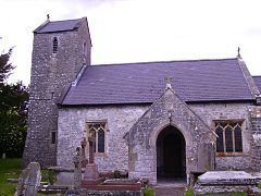
Within Llandow is a small medieval parish church, whose history dates back to the 11th century, with a saddleback tower dedicated to the Holy Trinity.
Adjacent to the village is a disused airfield that was once home to a World War II RAF station, part of which has now been converted into the Llandow Circuit for motorsports, next to which is the South Wales Karting Centre, home to the Llandow Kart Club.
Llandow air disaster 1950
On 12 March 1950 RAF Llandow was the site of the Llandow air disaster, when an airliner returning Welsh rugby fans from an international match in Belfast crashed on approach in the nearby village of Sigingstone. With the deaths of 80 passengers and crew, the crash was at the time the worst air disaster in history.
National Eisteddfod venue
From 3–11 August 2012, a disused airfield near Llandow hosted the National Eisteddfod of Wales.