
- elevation 4,501 ft (1,372 m) - average 534 cu ft/s (15 m/s) Length 901 km Source Flatiron Butte Bridges Lost Bridge | - elevation 1,860 ft (567 m) Discharge 15.12 m³/s Basin area 21,523 km² | |
 | ||
- max 110,000 cu ft/s (3,115 m/s) Mouths | ||
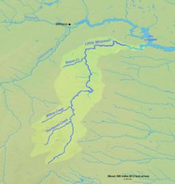
The Little Missouri River is a tributary of the Missouri River, 560 miles (901 km) long, in the northern Great Plains of the United States. Rising in northeastern Wyoming, in western Crook County about 15 miles (24 km) west of Devils Tower, it flows northeastward, across a corner of southeastern Montana, and into South Dakota. In South Dakota, it flows northward through the Badlands into North Dakota, crossing the Little Missouri National Grassland and both units of Theodore Roosevelt National Park. In the north unit of the park, it turns eastward and flows into the Missouri in Dunn County at Lake Sakakawea, where it forms an arm of the reservoir 30 miles (48 km) long called Little Missouri Bay and joins the main channel of the Missouri about 25 miles (40 km) northeast of Killdeer.
Map of Little Missouri River, North Dakota, USA
The highly seasonal runoff from badlands and other treeless landscapes along the Little Missouri carries heavy loads of eroded sediment downstream. The sedimentary layers, which extend from the headwaters in Wyoming all the way to the mouth in North Dakota, vary in age, but most of the beds along the river belong to the Bullion Creek and Sentinel Butte formations, both deposited during the Paleocene (about 66 to 56 million years ago). The deposits include siltstone, claystone, sandstone, and lignite coal laid down in a coastal plain during the Laramide orogeny.