
Website www.dunncountynd.org Founded 1883 | Area 5,392 km² Population 4,162 (2013) | |
 | ||
Points of interest Little Missouri State Park, Dunn County Historical, High Plains Cultural Center, Lake Ilo National Wildlife R, Little Missouri State Par | ||
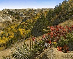
Theodora birdbear on killdeer mountains in dunn county north dakota
Dunn County is a county located in the U.S. state of North Dakota. As of the 2010 census, the population was 3,536. Its county seat is Manning. The county was created by the 1883 Dakota Territory legislature and named for John Piatt Dunn, who opened the first drugstore in North Dakota and was a civic and commercial leader during the early history of Bismarck. The county government was first organized on February 10, 1908.
Contents
- Theodora birdbear on killdeer mountains in dunn county north dakota
- Map of Dunn County ND USA
- Geography
- Adjacent counties
- Major highways
- National protected area
- 2000 census
- 2010 census
- Sites of interest
- Cities
- Census designated place
- Unincorporated communities
- References
Map of Dunn County, ND, USA
Geography
According to the U.S. Census Bureau, the county has a total area of 2,082 square miles (5,390 km2), of which 2,008 square miles (5,200 km2) is land and 74 square miles (190 km2) (3.5%) is water. It is the fifth-largest county in North Dakota by total area.
Dunn County is somewhat unusual among western North Dakota counties. Like other counties in the region, it has both prairie and badlands areas. Located in the northwest part of the county are the Killdeer Mountains, which are more accurately described as hills. These hills help create a mini-ecosystem on the southern edge of the Little Missouri badlands, which has a greater abundance of aspen forests and wildlife than is typically found in southwestern North Dakota.
The northwest corner of the county, northwest of the Killdeer Mountains, features many square miles of bur oak forest, mainly on the north-facing slopes of the hills. Bur oak and quaking aspen, though native to North Dakota, are sparse in western North Dakota, with Dunn County being a notable exception.
Adjacent counties
Major highways
National protected area
2000 census
As of the census of 2000, there were 3,600 people, 1,378 households, and 986 families residing in the county. The population density was 2 people per square mile (1/km²). There were 1,965 housing units at an average density of 1 per square mile (0/km²). The racial makeup of the county was 86.58% White, 0.03% Black or African American, 12.44% Native American, 0.08% Asian, and 0.86% from two or more races. 0.75% of the population were Hispanic or Latino of any race. 43.2% were of German and 16.6% Norwegian ancestry.
There were 1,378 households out of which 32.00% had children under the age of 18 living with them, 60.30% were married couples living together, 7.20% had a female householder with no husband present, and 28.40% were non-families. 25.30% of all households were made up of individuals and 12.30% had someone living alone who was 65 years of age or older. The average household size was 2.57 and the average family size was 3.11.
In the county, the population was spread out with 27.40% under the age of 18, 5.80% from 18 to 24, 23.60% from 25 to 44, 25.90% from 45 to 64, and 17.40% who were 65 years of age or older. The median age was 41 years. For every 100 females there were 104.20 males. For every 100 females age 18 and over, there were 103.60 males.
The median income for a household in the county was $30,015, and the median income for a family was $34,405. Males had a median income of $26,226 versus $17,143 for females. The per capita income for the county was $14,624. About 13.80% of families and 17.50% of the population were below the poverty line, including 21.70% of those under age 18 and 14.20% of those age 65 or over.
2010 census
As of the 2010 United States Census, there were 3,536 people, 1,401 households, and 977 families residing in the county. The population density was 1.8 inhabitants per square mile (0.69/km2). There were 2,132 housing units at an average density of 1.1 per square mile (0.42/km2). The racial makeup of the county was 84.9% white, 12.7% American Indian, 0.3% Asian, 0.2% black or African American, 0.2% from other races, and 1.7% from two or more races. Those of Hispanic or Latino origin made up 1.1% of the population. In terms of ancestry, 57.6% were German, 20.3% were Norwegian, 8.5% were Czech, 6.0% were Russian, 5.7% were Irish, 5.3% were English, and 1.8% were American.
Of the 1,401 households, 28.1% had children under the age of 18 living with them, 57.7% were married couples living together, 6.6% had a female householder with no husband present, 30.3% were non-families, and 26.5% of all households were made up of individuals. The average household size was 2.43 and the average family size was 2.93. The median age was 44.4 years.
The median income for a household in the county was $48,707 and the median income for a family was $65,122. Males had a median income of $37,270 versus $23,599 for females. The per capita income for the county was $24,832. About 6.2% of families and 8.6% of the population were below the poverty line, including 7.5% of those under age 18 and 12.1% of those age 65 or over.