
OS grid reference SU050366 Post town SALISBURY Dialling code 01722 | Sovereign state United Kingdom Postcode district SP3 | |
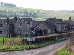 | ||
Little langford bed and breakfast
Little Langford is a hamlet and former civil parish in Wiltshire, England. Its nearest town is Wilton, about 5 miles (8.0 km) to the southeast. It is in the Wylye valley, to the south of the river; the grass fields adjacent to the river were traditionally flood meadows.
Contents
Map of Little Langford, Salisbury, UK
The civil parish was added to Steeple Langford parish in 1934.
Notable sights
The Anglican Church of St Nicholas of Mira is Grade II* listed. It dates from the 12th century and was restored in 1864 by T.H. Wyatt.
Little Langford farmhouse (c.1858) has a Victorian Gothic entrance tower, lancet windows and crenellations. The farm is over 580 ha (1,400 acres) and is home to a 200 cow dairy unit.
Just to the south of the village lies the Iron Age hill-fort of Grovely castle.
References
Little Langford Wikipedia(Text) CC BY-SA