
Reference no. DE: 26784 | River system Rhine | |
 | ||
Main source On the heights of the Neroth woods in the county of Vulkaneifelca. 584 m above sea level (NHN) | ||
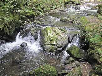
The Little Kyll German: Kleine Kyll, pronounced: "kill") is a 23.9-kilometre-long orographically right-hand tributary of the Lieser.
Contents
Map of Kleine Kyll, Germany
Course
The Little Kyll rises two kilometre northeast of Neroth on the heights of the Neroth woods in the county of Vulkaneifel in the German state of Rhineland-Palatinate. It flows in a southerly direction through the municipalities of Neroth, Oberstadtfeld, Niederstadtfeld and Schutz and empties into the Lieser south of Manderscheid, Bernkastel-Wittlich.
Tributaries
The tributaries of the Little Kyll include the following (in a downstream direction):
Recreation
In the area between Oberstadtfeld and Bleckhausener Mühle/Meerfeld the Kosmos Cycleway (Kosmosradweg) runs parallel to the Kleine Kyll.
At the confluence with the Horngraben, south of Manderscheid is the gorge of Wolfsschlucht as well as a waterfall.