
Local time Saturday 8:57 PM | Elevation 1,080 m Number of airports 1 | |
 | ||
Weather 26°C, Wind NE at 5 km/h, 53% Humidity | ||
Barefoot peace walk lira uganda
Lira is a city in the Northern Region of Uganda. It is the main municipal, administrative, and commercial centre of Lira District. Lira was the main city of the defunct Lango District, which corresponds geographically with the current Lango sub-region.
Contents
- Barefoot peace walk lira uganda
- Map of Lira Uganda
- Town of lira uganda
- Location
- Population
- Transport
- Power line
- Points of interest
- References
Map of Lira, Uganda
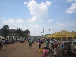
Town of lira uganda
Location
Lira is approximately 110 kilometres (68 mi), by road, southeast of Gulu, the largest city in the Northern Region, along the highway between Gulu and Mbale. This is approximately 320 kilometres (200 mi), by road, north of Kampala, the capital of Uganda and its largest city. Lira is approximately 124 kilometres (77 mi) northwest of Soroti, the nearest large town to the south. The coordinates of Lira are 2°14'50.0"N 32°54'00.0"E (Latitude:02.2472; Longitude:32.9000).
Population
The 2002 national census estimated the population of Lira at 80,900. In 2010, the Uganda Bureau of Statistics (UBOS) estimated the population at 105,100. In 2011, UBOS estimated the mid-year population at 108,600. In August 2014, the national population census put the population at 99,059.
Transport
Lira is served by a railway station of the Uganda Railways network. The town is also served by a public civilian airport, Lira Airport, administered by the Civil Aviation Authority of Uganda.
Power line
An 80 kilometres (50 mi) 132 kilovolt electricity line from the Karuma Power Station is under construction to a substation in Lira, under the supervision of Intec Gopa International Energy Consultants GmbH of Germany.
Points of interest
The following additional points of interest lie within the town limits or close to the edges of town: