
- summer (DST) CEST (UTC+2) Area 30.57 km² | Elevation 233 m Local time Saturday 4:43 PM | |
 | ||
Weather 9°C, Wind W at 31 km/h, 75% Humidity | ||
Lipn k nad be vou 2012
Lipník nad Bečvou ( [ˈlɪpɲiːk ˈnad bɛtʃvou̯]; German: Leipnik) is a small town located in the Olomouc Region, in the eastern part of the Czech Republic. The nearest larger towns are Přerov and Hranice, approximately ten to twelve kilometers (six to eight miles) distant.
Contents
Map of 751 31 Lipn%C3%ADk nad Be%C4%8Dvou, Czechia
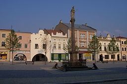
The town lies in the vicinity of the castle Helfštýn, at the same level as Moravská Brána, the Moravian Gate (a small pass through the mountains). It is an ancient town with a large square (T.G. Masaryk Square) in the shape of the letter L and very interesting set of sights. For several centuries, Lipnik was an important waypoint on the Amber Road. It was a fortified town, and it still retains a large portion of its medieval walls and towers. There is a ring road that runs around the outside of the ancient walls, with the best view of the walls to be seen from Komenského sady. The town may be proud of the well-established historical centre with a Renaissance town hall, baroque fountains and Renaissance houses with arcades. Just next to the square, St. James´ Parish Church with its unique belltower offers a fine view of the square. The church itself is built in a Baroque style and is highly ornamented inside. In addition, there is a Renaissance palace with a walled garden in the rear, a Piarist monastery with the St.Francis´ Serafín church and a synagogue. A large Jewish minority lived here; two unique cemeteries are the evidence of this.