
Congressional district At-large Website www.lincolncountymt.us Founded 1909 Unemployment rate 10.3% (Apr 2015) | Area 9,518 km² Population 19,460 (2013) | |
 | ||
Rivers Kootenay River, Boiling Springs Creek, Robertson Creek | ||
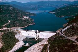
Kootenai falls lincoln county montana
Lincoln County is a county located in the U.S. state of Montana. As of the 2010 census, the population was 19,687. Its county seat is Libby. The county was founded in 1909 and named for President Abraham Lincoln.
Contents
- Kootenai falls lincoln county montana
- Map of Lincoln County MT USA
- Geography
- Adjacent counties and county equivalents
- National protected areas
- 2000 census
- 2010 census
- Cities
- Towns
- Unincorporated communities
- References
Map of Lincoln County, MT, USA
This heavily wooded and mountainous county once was part of Flathead County until residents of Libby and Eureka petitioned the state legislature for separation. Libby won an election over Eureka to host the county seat.
Geography
According to the U.S. Census Bureau, the county has a total area of 3,675 square miles (9,520 km2), of which 3,615 square miles (9,360 km2) is land and 62 square miles (160 km2) (1.7%) is water. The county borders the Canadian province of British Columbia to the north. The lowest point in the state of Montana is located on the Kootenai River in Lincoln County, where it flows out of Montana and into Idaho. Upstream, Libby Dam backs up huge Lake Koocanusa (combination name of Kootenai, Canada, USA) into Canada's British Columbia.
Adjacent counties and county-equivalents
National protected areas
2000 census
As of the census of 2000, there were 18,837 people, 7,764 households, and 5,333 families residing in the county. The population density was 5 people per square mile (2/km²). There were 9,319 housing units at an average density of 3 per square mile (1/km²). The racial makeup of the county was 96.09% White, 0.11% Black or African American, 1.20% Native American, 0.31% Asian, 0.04% Pacific Islander, 0.39% from other races, and 1.86% from two or more races. 1.44% of the population were Hispanic or Latino of any race. 23.6% were of German, 12.0% English, 10.2% American, 9.8% Norwegian and 9.4% Irish ancestry. 96.5% spoke English, 1.7% German and 1.3% Spanish as their first language.
There were 7,764 households out of which 29.10% had children under the age of 18 living with them, 57.10% were married couples living together, 7.80% had a female householder with no husband present, and 31.30% were non-families. 26.70% of all households were made up of individuals and 10.00% had someone living alone who was 65 years of age or older. The average household size was 2.40 and the average family size was 2.90.
In the county, the population was spread out with 25.30% under the age of 18, 5.50% from 18 to 24, 24.20% from 25 to 44, 29.70% from 45 to 64, and 15.20% who were 65 years of age or older. The median age was 42 years. For every 100 females there were 102.70 males. For every 100 females age 18 and over, there were 100.50 males.
The median income for a household in the county was $26,754, and the median income for a family was $31,784. Males had a median income of $30,299 versus $20,600 for females. The per capita income for the county was $13,923. About 14.20% of families and 19.20% of the population were below the poverty line, including 26.40% of those under age 18 and 10.80% of those age 65 or over.
2010 census
As of the 2010 United States Census, there were 19,687 people, 8,843 households, and 5,608 families residing in the county. The population density was 5.4 inhabitants per square mile (2.1/km2). There were 11,413 housing units at an average density of 3.2 per square mile (1.2/km2). The racial makeup of the county was 95.9% white, 0.9% American Indian, 0.3% Asian, 0.1% black or African American, 0.4% from other races, and 2.3% from two or more races. Those of Hispanic or Latino origin made up 2.3% of the population. In terms of ancestry, 31.5% were German, 15.7% were Irish, 15.3% were English, 10.2% were Norwegian, and 3.3% were American.
Of the 8,843 households, 23.2% had children under the age of 18 living with them, 52.0% were married couples living together, 7.4% had a female householder with no husband present, 36.6% were non-families, and 30.6% of all households were made up of individuals. The average household size was 2.20 and the average family size was 2.72. The median age was 48.9 years.
The median income for a household in the county was $30,823 and the median income for a family was $39,600. Males had a median income of $40,944 versus $24,965 for females. The per capita income for the county was $19,626. About 13.7% of families and 18.6% of the population were below the poverty line, including 28.2% of those under age 18 and 12.1% of those age 65 or over.