When the Spanish arrived, they divided Peru (very simplistically) into three main regions: the coastal region (11.6% of Peru), that is bounded by the Pacific Ocean; the highlands (28.1% of Peru), that is located on the Andean Heights, and the jungle, that is located on the Amazonian Jungle (Climate of Peru). But Javier Pulgar Vidal (es), a geographer who studied the biogeographic reality of the Peruvian territory for a long time, proposed the creation of eight Natural Regions. In 1941, he presented his thesis "Las Ocho Regiones Naturales del Perú" at the III General Assembly of the Pan-American Institute of Geography and History.
These eight Peruvian regions are:
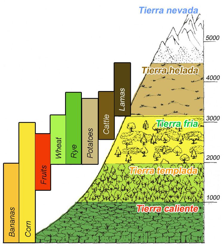
Chala or Coast (subtropical dry and tropical savanna)YungasFluvial YungaLoma-VegetationQuechuaSuni or JalcaPunaJancaRupa - Rupa or Highland JungleOmagua or Lowland JungleSea level, estimated 22 - 24°C (75°F, but the cold Humboldt Current generates fog on the coast side);Tierra caliente (Hot land, tropical) up to 2,500 ft (about 750 m - 1,000 m).Crops: Cacao, Banana, Sugarcane, Manioc, Sweet Potatoes, Yams.Tierra templada (Temperate land, subtropical) up to 6,000 ft (about 1,850 m – 2,000 m)(the warmest month has an average temperature of below 22°C or 72°F).
Crops: Coffee, Tobacco, Maize, Coca, Peruvian Pepper (Schinus molle), Avocado, Guave (Psidium guajava), Cherimoya, Plum, Citrus fruits.Tierra fría (Cool land, temperate) below 12,000 ft (about 3,600 m, treeline)(the warmest month has an average temperature of below 18°C or 64°F).
Crops: Potato, Maize, Squash, Passionfruit, Papaya, Peach, Wheat, Rye, and Barley. Farming of cattle.Tierra helada (Cold land) above 12,000 ft (about 3,600 m)(the definition of treeline of Coniferae: the warmest month has an average temperature of below 10°C or 50°F ).
Crops above tree line: Quinoa, Cañigua, Mashua, Oca, Tarhui, Broad beans and Ulluco. Farming of Sheep, Llamas and Alpacas.Terrestrial Biome Type 10: Montane grasslands and shrublands
Tierra Nevada (Janca), above the snow line, 15,000 ft (about 4,500 m - 5,000 m)(just warmer than -1°C over rocks or just warmer than -3°C over snow, annual mean temperature).
The Peruvian geographer Javier Pulgar Vidal divided Peru in 8 regions (traditionally, it was costa, sierra and selva):
Map from República del Perú - Instituto Geográfico Nacional
Chala (West, Pacific Coast) 0– 500 mOmagua (Lowland jungle or Selva baja, Amazonic rainforest) 80– 400 mRupa-Rupa (Highland jungle, Selva alta) 400– 1,000 mYunga (Aymaran for "Warm Lands", Cloud forest)Loma-Vegetation (West, "Yunga costal" at the north of Peru) 450– 600 mFluvial Yungas (East, "Yunga fluvial") 1,000- 2,300 mQuechua (East, High valleys) 2,300– 3,500 mSuni (or Jalca or Sallqa too, high plateaus and cliffs) 3,500– 4,100 mPuna (means "mountain top") 4,100– 4,800 mJanca (means white) above 4,800 m, permafrost, rocks, snow and ice Biomes & Ecoregions nearby:Tropical and subtropical moist broadleaf forests
Bolivian Yungas Peruvian Yungas Southwest Amazon moist forests Montane grasslands and shrublands
Central Andean dry puna Central Andean puna Central Andean wet puna Deserts and xeric shrublands
Atacama Desert Sechura Desert Mouth of the Amazon River, Atlantic OceanBelém, Brazil, 24 m, annual mean temperature 26.0°CGurupa varzea (NT0126) Manaus, Brazil, 72 m, annual mean temperature 26.6°CMonte Alegre varzea (NT0141) Purus varzea (NT0156) Colombia - Peru - Brazil borderLeticia, Colombia, 84 m, annual mean temperature 25.8°CTierra Caliente or Tropical rainforestOmagua or Selva baja (Southwest Amazon moist forests - NT0166) Iquitos, Peru, 126 m, annual mean temperature 26.2°CRupa-Rupa or Selva alta (Iquitos varzea - NT0128) Yunga fluvial (more than 5°C colder than the Peruan Tropics)Peruvian Yungas (NT0153) Quechua (High valleys, more than 10°C colder than the Peruan Tropics)TreelineTierra HeladaSuni (plateau)Mountain passPuna (mountain slope)Central Andean wet puna (NT1003) Central Andean puna (NT1002) "Andean-Alpine desert"Snow lineTierra Nevada or JancaPeakExplanations:
Region, altitude (m); avg annual precipitation (mm); avg annual temperature (°C);Peruvian Highland Rainforest (Tropical climate), Cloud forest (Subtropical climate) and Temperate forest (Temperate climate);Cusco reference, estimated avg annual temperature (°C, Lowland Rainforest or Selva baja gets more rain, so it is more cloudy, so it is cooler);Snow line reference, Humboldt cold current/ Pacific climate influence, estimated avg annual temperature (°C).Cuzco, Peru; 3,249 m; avg annual temperature 12.5 °C; avg annual precipitation 736 mm.Lima, Peru; 30 m; avg annual temperature 19.2 °C (fog influence); avg annual precipitation 15 mm.Altitudinal zonation: Kallawaya Region, around Charazani, Bolivia (border to Peru).
GlacierAltitude: 5,900- 5,200 m, Annual mean temperature: below 0 °C, Agriculture: noneHigh Mountain Desert, Werneria ciliolata on screeAltitude: 5,200- 5,000 m, Annual mean temperature: below 0 °C - 0 °C, Agriculture: none.Grass ZoneCalamagrostis minima Steppe,Altitude: 5,000- 4,600 m, Annual mean temperature: 0- 3.5 °C, Farming: alpacas, lamas.Pycnophyllum Steppe,Altitude: 4,600- 4,300 m, Annual mean temperature: 3.5- 7.5 °C, Farming: alpacas, lamas.Aciachne Humid Grassland,Altitude: 4,300- 3,900 m, Annual mean temperature: 7.5- 10.0 °C, Farming: alpacas, lamas, pigs; Agriculture: bitter potatoes, (oca), (oat); Fallow land: more than 8 years.Shrub ZoneSatureja Shrub (westslope), Baccharis pentandii Shrub, with Berberis (eastslope),Altitude: 3,900- 3,600 m, Annual mean temperature: 10.0- 11.5 °C, Farming: sheep; Agriculture: potatoes, oca, ulluco, barley; Fallow land: 3 to 4 years.Mutisia Shrub (westslope), Baccharis pentlandii Shrub, with Siphocampylus (eastslope),Altitude: 3,600- 2,700 m, Annual mean temperature: 11.5- 16.5 °C, Farming: sheep, cattle; Agriculture: wheat, (barley), peas, beans, maize up to 3,500 m with crop rotation.Kaunia longipetiolata Shrub,Altitude: 3,200- 2,700 m, Annual mean temperature: 13.5- 16.5 °C, Farming: cattle; Agriculture: maize, wheat, beans, spring potatoes, use of fertilizers, no crop rotation.Highland Rainforest,Altitude: below 2,700 m, Annual mean temperature: over 17.0 °C, Farming: cattle; Agriculture: tropical fruits, oranges, coffee, coca at around 2,000 m.