
Length 31 km | ||
 | ||
The Lester River, is a 19.3-mile-long (31.1 km) tributary of Lake Superior, in northeastern Minnesota in the United States. It drains an area of 58 square miles (150 km2).
Contents
Map of Lester River, Minnesota, USA
Course
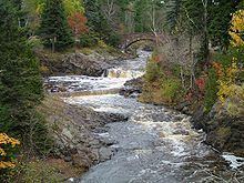
The Lester River flows for its entire length in southern Saint Louis County. It rises in Gnesen Township and flows generally southeastwardly through the city of Rice Lake and Lakewood Township, turning southward as it nears Lake Superior. It flows into the lake in eastern Duluth.
Lester River is known as Basaabikaa-ziibi in Ojibwe, meaning "Rocky Canyon River", though Joseph Gilfillan translated its name as "River that comes through a worn hollow place in the rock," as the river passes through a canyon between Lester Park, where Amity Creek joins the Lester River, and the mouth of the river.
History
Lester River bears the name of an early settler.
Historical structures
Along the Lester River are two structures listed on the National Register of Historic Places. They are: