
- location Cambrian Hill Mouth Barwon River | - elevation 325 m (1,066 ft) - elevation 60 m (197 ft) | |
 | ||
- left Wilson Creek (Victoria), Williamson Creek, Cargerie Creek | ||
The Leigh River is a perennial river of the Corangamite catchment, located in the Central Highlands region of the Australian state of Victoria.
Contents
- Map of Leigh River Inverleigh VIC Australia
- Location and features
- Communities and bridge crossings along the river
- Etymology
- References
Map of Leigh River, Inverleigh VIC, Australia
Location and features
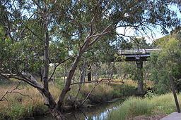
The Leigh River is a major tributary and catchment of the Barwon River. Fed by the Yarrowee River that rises near Ballarat, the Yarrowee reaches its confluence to form the Leigh in the vicinity of Cambrian Hill and Golden Plains Shire. The Leigh River rises below Mount Mercer and flows generally south, joined by three minor tributaries before reaching its confluence with the Barwon River, southeast of the central business district of Inverleigh. The river descends 265 metres (869 ft) over its 61-kilometre (38 mi) course.
Communities and bridge crossings along the river
There are several crossings over the Leigh River, including road, rail and pedestrian. Some additional roads allow passage through shallow sections of the river when the water levels are low.
Etymology
The Wathaurong Indigenous Australian people named the river Yaramlok, and it is believed that the name Yarrowee, which is used for the upper reaches, was derived from this name.
It is believed that the name Leigh River was given by the surveyor J.H. Wedge who arrived in 1835, probably naming the river after his Tasmanian farm 'Leighlands'.