
Population 362 (in 2011) Civil parish Leigh Post town Swindon | OS grid reference SU062921 Unitary authority Dialling code 01285 | |
 | ||
Leigh is a village and civil parish in north Wiltshire, England, 1.5 miles (2.4 km) southeast of Ashton Keynes and 2.5 miles (4.0 km) west of Cricklade. It is on the edge of the Cotswold Water Park and near to the border with Gloucestershire.
Contents
Map of Leigh, Swindon, UK
The infant River Thames forms part of the northern boundary of the parish. Near the river is Upper Waterhay Meadow, a biological Site of Special Scientific Interest.
Church
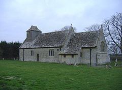
The first All Saints Church dated from the 13th century and was at Waterhay, north of the village. In 1896 parts of it were rebuilt by Charles Ponting at a site closer to the village and less prone to flooding. The chancel of the old church still stands; both it and the newer church are Grade II* listed.
References
Leigh, Wiltshire Wikipedia(Text) CC BY-SA