
Population (2008) 3,746 Area 84.93 km² | Region Occitanie Canton Lectoure Time zone CET (UTC+1) Local time Tuesday 7:27 PM | |
 | ||
Weather 13°C, Wind W at 5 km/h, 74% Humidity | ||
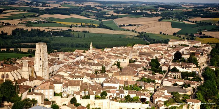
Lectoure ([lɛktuʀ]; Occitan: Leitora [lejˈtuɾɔ]) is a commune in the Gers department in the Occitanie in southwestern France.
Contents
- Map of 32700 Lectoure France
- Geography
- History
- Sites of interest
- Way of St James
- Cuisine
- Notable people
- References
Map of 32700 Lectoure, France
It is located 32 km (20 mi) north of Auch, the capital of the department, 30 km (19 mi) south of Agen and approximately 76 km (47 mi) northwest of Toulouse.
Geography
The village is located on the right bank of the Gers, which flows north through the western part of the commune. The river Auroue forms part of the commune's southeastern and northeastern borders.
History
Lectoure was a prehistoric oppidum, capital of Lactorates.The barbarian invasions successive forcing residents to reconsider the height, to raise the walls and make Lectoure a stronghold for centuries.
Sites of interest
Lectoure has been designated as a "town of art and history" (French: Villes et Pays d'Art et d'Histoire) by the French Ministry of Culture and Communication since 1985. The town hall was built between 1676 and 1682 by bishop Hugues de Bar.
Way of St. James
Lectoure is a town on the Via Podiensis, one of the three major French arms of the Way of St. James. This route is followed by those making the pilgrimage from Le Puy by way of Saint-Jean-Pied-de-Port to Santiago de Compostella in northwest Spain. Pilgrims arrive at Lectoure after Miradoux and next pass through La Romieu.
Cuisine
Locally produced Armagnac and foie gras are available and popular delicacies.