
Length 175 km Source elevation 630 m | Basin size 1,227 km (474 sq mi) Discharge 9 m³/s Mouth Garonne | |
 | ||
Sources Pyrenees, Plateau de Lannemezan | ||
The Gers ([ʒɛːʁ]) (Occitan: Gers) is a 178-kilometre (111 mi) long river in southern France, left tributary of the Garonne.
Contents
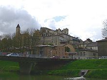
Its source is in the foothills of the Pyrenees, near Lannemezan. It flows north through the départements Hautes-Pyrénées, Gers and Lot-et-Garonne. It flows into the Garonne in Layrac, near Agen. The city Auch lies along the river Gers. It gives its name to the Gers département.
ToponymyEdit
The name of the Gers appears in the sixth century as Ægirtius, de Egircio flumine and Gircius. It is known as in flumine Gersio in 817 and as Iercius in the 13th century.
Departments and citiesEdit
The Gers passes through the following departments and main towns:
References
Gers (river) Wikipedia(Text) CC BY-SA