
 | ||
Similar Visserijmuseum, Klaarkamp Abbey, Windlust - Burum, Jardín botánico De Kruid, Boschplaat | ||
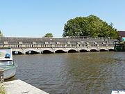
The Lauwers ( [ˈlʌuʋərs]) is a river in the Netherlands. It forms part of the border between the provinces of Friesland and Groningen. From the 730's to Widukind's defeat in 785 it was part of the border of the Frankish Empire.
Map of Lauwers, Burum, Netherlands
The former Lauwerszee and the present-day Lauwersmeer are both named after the river, which as a small stream has its source southeast of the village of Surhuisterveen. Near Gerkesklooster/Stroobos it crosses the Prinsesmargrietkanaal/van Starkenborghkanaal.
The Lauwers achieves the width of a true river at the point where it gains its tributary, the Oude Vaart, near the Schalkendam. Further along its course, the Lauwers splits into two branches, the Frisian Oude Lauwers and the Zijldiep, in Groningen province.
The Lauwers meets the sea at the Wadden Sea, emptying into a channel between the islands of Schiermonnikoog and Rottumerplaat/Rottumeroog, which can be viewed as the continuation of the river.