
Population 80 (2011 census) Postal code 4871 | Postcode(s) 4871 Local time Tuesday 12:42 AM | |
 | ||
Weather 26°C, Wind E at 6 km/h, 87% Humidity | ||
Laura is a small town and locality in Cook Shire, Cape York Peninsula in northern Queensland, Australia. It is on the only road north towards the tip of the peninsula, and is the centre for the largest collection of prehistoric rock art in the world. It also forms the northern apex of the "Scenic Triangle" between Cooktown, Lakeland, and Laura. In the 2011 census, Laura had a population of 80 people.
Contents
Map of Laura QLD 4892, Australia
Some of the world's most extensive and ancient rock painting galleries surround the tiny town of Laura, some of which are available for public viewing. Laura has an Interpretive Centre from which information on the rock art and local Aboriginal culture is available and tours can be arranged.
Laura is only a few kilometres from the southern entrance to Lakefield National Park.
History
Aboriginal people have made their home in the Laura River valley for at least 50,000 years. In the wet season, they would camp under rock shelters on the high ground. This is where their rock art can be found.
Some of the earliest pastoral leases on Cape York Peninsula were taken up in the Laura district. However, the town of Laura did not develop until the discovery of gold on the Palmer River.
In 1873 gold was discovered on the Palmer River. Travellers coming from Cooktown to the Palmer Goldfields would cross the Laura River at Laura. This was a very violent period, as local aboriginal clans waged a war of resistance. A Native Mounted Police camp was established near the Lower Laura crossing to protect travellers.
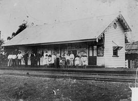
During the gold boom a railway line was planned between Cooktown and the Palmer gold fields. By 1888 the line had been built to Laura.
Laura Post Office opened on 8 October 1888.
An impressive bridge over the Laura River was opened, to great fanfare, in 1891. However, since the Palmer gold fields were in decline, a new Queensland government decided to abandon the project. Only one train ever crossed the bridge - the train that ran on the day that it opened.
The rail line contributed to the growth of Laura. It was used by miners and by peninsula cattle properties. The Cooktown to Laura Railway finally closed in 1961.
It was during the 1960s that Quinkan rock art galleries were reported by Percy Trezise, an airline pilot who surveyed the area from the air for likely sites and later walked in to rediscover them.
At the 2006 census, Laura and the surrounding area had a population of 225.
Laura State School opened in March 1889 and currently caters for students from Prep to Year six.
Heritage listings
Laura has a number of heritage-listed sites, including: