
Country United States County Larimer FIPS code 08-43220 Elevation 1,530 m Zip code 80535 Area code 970 | Time zone MST (UTC-7) GNIS feature ID 0204672 Area 15.8 km² Population 2,691 (2000) | |
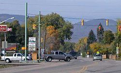 | ||
3417 vernon drive laporte colorado
Laporte (also spelled LaPorte) is a census-designated place (CDP) in Larimer County, Colorado, United States. The population was 2,691 at the 2000 census. The Laporte Post Office has the ZIP Code 80535.
Contents
- 3417 vernon drive laporte colorado
- Map of Laporte CO USA
- Flood in laporte colorado
- History
- Geography
- Demographics
- Fiction
- References
Map of Laporte, CO, USA
The community is located on the Cache La Poudre River northwest of Fort Collins, close to where the river emerges from the foothills of the Rocky Mountains.
Flood in laporte colorado
History
The town was first settled by French-Canadian fur trappers and mountain men. It was the gateway to all the mountainous region lying north of the South Platte River and extending from the Plains to the Continental Divide. The trappers built cabins here along the Cache la Poudre River as early as 1828, making it the first white settlement in Larimer County, Colorado. According to legend, a group of fur traders had earlier stashed supplies (including gunpowder) in a cache along the river near Laporte, and that is how the river got its name. It became the home of Antoine Janis in 1844, who is often noted as the first permanent white settler north of the Arkansas River. A band of intrepid mountaineers, hunters and trappers made LaPorte their headquarters for fur catching and trading operations. The settlement increased in numbers, including one hundred fifty lodges of Arapahoe Indians who settled peacefully along the river, and in the valley. The town was named by the fur trappers, many with Native American wives, who settled in the area in the mid-19th century. The name la porte means "the door" in French.
The winter of 1849 brought Kit Carson and his company of trappers to the Cache la Poudre where they set up camp. In 1860 a town company was organized. It was originally called Colona. Between fifty and sixty log dwellings were erected that year along the banks of the Cache la Poudre River in the valley and in November 1861, the territorial legislature designated Laporte as the county seat. In 1862, the town of Colona changed its name to LaPorte, and was named the headquarters of the Mountain Division of the Overland Trail Stage Route. The first post office opened, and a stage stop was built on the Overland Trail. A station was erected right along the river, very near where the present Overland Trail crosses the river. Mrs Taylor, wife of the first stationmaster, was a "good cook" and "gracious hostess", and as described by one diarist, knows "what to do with beans and dried apples." The stage fare from Denver to LaPorte was $20.00. The first bridge over the Cache la Poudre River was built as a toll bridge, and during the rush to California, numerous wagons and stage coaches crossed it every day. The toll charged was anywhere from $.50 to $8.00, depending on what source of information is used. In 1864, the bridge was washed away by a flood, and a ferry was rigged up and used for several years until the county built another bridge.
LaPorte soon became a bustling business and supply center for emigrants, with wagon trains and stage coaches constantly passing through. There were four saloons, a brewery, a butcher shop, two blacksmith shops, a general store and a hotel. The store was a thriving business, sometimes making as much as $1000 per day. LaPorte was the most important settlement north of Denver, housing the Stage Station, the County Court House, the military, Indians, and trappers. In 1862, Camp Collins was established by the U.S. Army along the river to protect the stage line from attack by Native Americans. Also that same year, the Laporte Townsite Company claimed 1,280 acres (5.2 km2) of land for the town. In 1863 the 13th Kansas volunteer infantry was stationed to Laporte, acting as escort for the Overland Stage on the trail to Virginia Dale. During the flood of 1864, the army camp was covered with water, and the soldiers had to suddenly flee to higher ground. In August of that year, Col. Collins came down from Laramie on an inspection tour, and decided to move the army camp to Fort Collins, down river about 6 miles.
Geography
Laporte is located at 40°38′2″N 105°8′56″W (40.633808, -105.148819).
According to the United States Census Bureau, the CDP has a total area of 6.1 square miles (16 km2), of which, 6.1 square miles (16 km2) of it is land and 0.04 square miles (0.10 km2) of it (0.49%) is water.
Demographics
As of the census of 2000, there were 2,691 people, 1,074 households, and 718 families residing in the CDP. The population density was 440.6 people per square mile (170.0/km²). There were 1,108 housing units at an average density of 181.4 per square mile (70.0/km²). The racial makeup of the CDP was 92.49% White, 0.22% African American, 1.08% Native American, 0.45% Asian, 2.34% from other races, and 3.42% from two or more races. Hispanic or Latino of any race were 8.06% of the population.
There were 1,074 households out of which 33.4% had children under the age of 18 living with them, 51.6% were married couples living together, 10.1% had a female householder with no husband present, and 33.1% were non-families. 24.7% of all households were made up of individuals and 5.8% had someone living alone who was 65 years of age or older. The average household size was 2.51 and the average family size was 3.01.
In the CDP, the population was spread out with 25.8% under the age of 18, 8.5% from 18 to 24, 32.0% from 25 to 44, 25.4% from 45 to 64, and 8.4% who were 65 years of age or older. The median age was 37 years. For every 100 females there were 102.9 males. For every 100 females age 18 and over, there were 100.6 males.
The median income for a household in the CDP was $46,630, and the median income for a family was $52,500. Males had a median income of $30,602 versus $25,571 for females. The per capita income for the CDP was $19,870. About 4.9% of families and 5.6% of the population were below the poverty line, including 9.6% of those under age 18 and none of those age 65 or over.
Fiction
In L. Neil Smith's North American Confederacy series of novels, beginning with The Probability Broach, an alternate-history LaPorte is one of the major cities of North America, occupying roughly half the area of Larimer County, and with a population of over two million people; whereas the city of Denver does not exist: In its place are the two small historic settlements of Saint Charles Town and Auraria.