
Time zone EST (UTC−5) Highways Route 329 Local time Sunday 1:03 PM Province Québec | Constituted January 1, 1948 Postal code(s) J0T 1V0 Area 48.8 km² Population 828 (2011) Area code 819 | |
 | ||
Website www.municipalite.lantier.qc.ca Weather -17°C, Wind W at 14 km/h, 51% Humidity | ||
Adt lifesaver gilles jones of lantier quebec fire and medical emergency
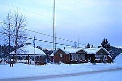
Lantier is a village and municipality in the Laurentides region of Quebec, Canada, part of the Les Laurentides Regional County Municipality.
Contents
- Adt lifesaver gilles jones of lantier quebec fire and medical emergency
- Map of Lantier QC Canada
- Demographics
- References
Map of Lantier, QC, Canada
Demographics
Population trend:
Private dwellings occupied by usual residents: 370 (total dwellings: 762)
Mother tongue:
References
Lantier, Quebec Wikipedia(Text) CC BY-SA