
OS grid reference SX1453 Unitary authority | Dialling code 01726 Post town Fowey | |
 | ||
Population 944 (2011 Census including Bodinnick) | ||
Lanteglos-by-Fowey (Old Cornish: Nant Eglos, meaning church valley) is a coastal civil parish in south Cornwall, England, United Kingdom. It is situated on the east side of the tidal estuary of the River Fowey which separates it from the town and civil parish of Fowey.
Contents
Map of Lanteglos, Fowey, UK
To the north, Lanteglos-by-Fowey is bounded by the parish of St Veep, to the east by the parish of Lansallos, and to the south by the sea. The parish is in the Liskeard Registration District and the population in the 2001 and 2011 census' was 994. and Penpol Creek forms part of the northern boundary.
The village of Lanteglos Highway is in the north of the parish.
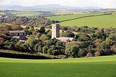
The parish church of Saint Wyllow is at Churchtown hamlet (50.334°N 4.608°W / 50.334; -4.608 (Saint Wyllow)) just over a mile (2 km) to the south. St Saviour church (a chapel-of-ease of the parish church) is situated in Polruan, the largest settlement in the parish.
The riverside village of Bodinnick lies to the west of the parish. A car ferry to Fowey departs from there.
The hamlet of Whitecross (50.346°N 4.616°W / 50.346; -4.616 (Whitecross)) lies between Lanteglos Highway and Bodinnick. It has a village hall.
The hamlet of Mixtow lies on the River Fowey to the west. There was a lime kiln here and a watermill to the north at Castle.
Pont Pill is a tidal creek which runs through the parish. The hamlet of Pont (50.334°N 4.608°W / 50.334; -4.608 (Pont)) lies on the stream running into the pill. There was a quay, granary, two limekilns, malt house, warehouse, corn mill, three watermills (dating from 1298, 1309 and 1423) a sawmill, beer house and blacksmith in Pont. An isolation hospital for sailors with Yellow Fever was built further down the pill toward Polruan.
The South West Coast Path runs along the southern coasts of the parish and much of the southern part of the parish lies in the Polruan to Polperro Site of Special Scientific Interest managed by the National Trust. Lantic Bay is a beach on the coast.
Parish church
The parish church, dedicated to St Wyllow, was built in the 14th century and refashioned in the 15th. The 16th century benchends and panels from family pews have been preserved in the Victorian restoration by E. H. Sedding. The church contains the brasses of Thomas de Mohun (d.1400) of Hall in Lanteglos (grandson of Reginald de Mohun and his wife Elizabeth FitzWilliams) and also a monument to John Mohun (d.1508) of Hall (great-grandson of Thomas de Mohun (d.1400)) and his wife Anne Code (d.1508), who both died within a day of each other of sweating sickness.