
River mouth Fowey estuary Basin area 169.1 km² Sources Bodmin Moor, Brown Willy | Discharge 4.78 m³/s Country United Kingdom Mouths Fowey, Fowey estuary | |
 | ||
Main source Bodmin Moor
298 m (978 ft) Cities Lostwithiel, Milltown, Cornwall Similar Bodmin Moor, Restormel Castle, Brown Willy, The Hurlers, Readymoney Cove | ||
The River Fowey (/ˈfɔɪ/ FOY; Cornish: Fowi) is a river in Cornwall, England, United Kingdom.
Contents
- Map of River Fowey United Kingdom
- Geology and hydrologyEdit
- Wildlife and conservationEdit
- RecreationEdit
- Ferry servicesEdit
- References
Map of River Fowey, United Kingdom
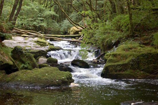
It rises at Fowey Well (originally Cornish: Fenten Fowi, meaning spring of the river Fowey) about 1-mile (1.6 km) north-west of Brown Willy on Bodmin Moor, not far from one of its tributaries rising at Dozmary Pool and Colliford Lake, passes Lanhydrock House, Restormel Castle and Lostwithiel, then broadens at Milltown before joining the English Channel at Fowey. The estuary is called Uzell (Cornish: Usel, meaning howling place). It is only navigable by larger craft for the last 7 miles (11 km). There is a ferry between Fowey and Bodinnick. The first road crossing going upstream is in Lostwithiel. The river has seven tributaries, the largest being the River Lerryn. The section of the Fowey Valley between Doublebois and Bodmin Parkway railway station is known as the Glynn Valley (Cornish: Glyn, meaning deep wooded valley). The valley is the route of both the A38 trunk road and the railway line (built by the Cornwall Railway in 1859). The railway line is carried on eight stone viaducts along this stretch (see Cornwall Railway viaducts).
Geology and hydrologyEdit
The upper reaches of the Fowey are mainly moorland giving way to woodland and farmland, predominantly livestock. This means that 63.6% of the catchment is grassland, with a further 18.3% woodland and 10.7% arable land. Of the remaining 7.5%, 2.6% is urban or built-up areas, 2.5% is mountain, heath and bog and the remainder is inland waters.
The catchment area of the River Fowey covers a total of 41,800 acres (65.3 sq. miles) consisting of kaolinised granite on Bodmin Moor, Devonian slates and grits, and valley gravels. Data collected by the National Water Archive shows that average flow at the Restormel monitoring station is 4.78 cubic m/s and is affected by the reservoirs at Colliford and Sibleyback and by abstraction of water for public supply.
The former quarry of the Glynn Valley China Clay Works has closed down and is now flooded. It was in operation from the 1940s but since 2015 the site has been used for camping.
Wildlife and conservationEdit
The river runs through two Sites of Special Scientific Interest (SSSI), one of which is also part of a National Nature Reserve (NNR). The Upper Fowey SSSI is a floodplain on the southern slopes of Bodmin Moor and is designated for its wet heath vegetation and herbaceous valley-floor mire communities. Lower down the river at Golitha Falls part of the woodland is designated a NNR and is within the Draynes Wood SSSI. At this point the river runs through a gorge and is of particular importance for ″lower plants″ such as liverworts, mosses and lichens. Golitha (pronounced Goleetha) is derived from the Cornish word for obstruction. There is a 1-3-mile (4.8 km) riverside walk, from the visitor car park. Golitha Falls is the site of Wheal Victoria copper mine
RecreationEdit
The Fowey valley is designated as an Area of Outstanding Natural Beauty so many hikers, holidaymakers and tourists visit the places of interest and eat freshly caught fish. The river has very pleasant sites and special paths made for hiking and walking along the banks and in the countryside surrounding the towns.
The River Fowey is famous for its sailing because of its natural harbour. In the past it has been visited by up to 7,000 yachts in one season. Almost all sections of the river have been paddled by kayakers and canoeists: the whitewater sections high up on the moor, all the way down to the estuary. Fowey has an excellent local chandlery.
Many fish can be caught in the River Fowey so many fishermen come to enjoy the excellent fishing conditions.
Ferry servicesEdit
Fowey to Polruan Passenger and Cycle Ferry. The summer service runs 1 May – 30 September from Whitehouse Slip until 1815 hrs. From 1830 hrs the service operates from Town Quay until 2300 hrs. Continuous service from 0715 hrs Monday – Saturday and 0900 hrs on Sunday. Please check notice board for further information during August. Winter service runs 1 October – 30 April leaving Town Quay. Monday – Saturday 0715 hrs until 1900 hrs continuous service. Sundays 1000 hrs until 1700 hrs continuous service. Ferry services are subject to weather conditions.
Fowey to Bodinnick Vehicle Ferry. The summer service operates 1 April – 31 October, starting at 0700 hrs Monday – Saturday and 0800 hrs on Sunday and running until 1900 hrs. The winter service operates 1 November – 31 March, and runs until 2045 hrs or dusk (whichever comes first). The service starts 0700 hrs Monday – Friday, 0800 hrs on Saturday and 0900 hrs on Sunday. N.B. Ferry services are subject to weather conditions.
Fowey to Mevagissey Passenger Ferry is a timetabled summer service between Fowey and Mevagissey leaving Whitehouse Slip. Journey time is around 40 minutes, please see leaflet or notice board for sailings. An alternative route to The Lost Gardens of Heligan, finishing the journey by foot or taxi. This service is dependent on weather