
Seat Ashton Time zone SAST (UTC+2) Area 4,518 km² Black african population 16.3% Native english speakers 3.1% | Wards 12 Municipal code WC026 White population 12.3% Native afrikaans speakers 82.5% Native sotho speakers 1.3% | |
 | ||
Gold bars for sale langeberg local municipality south africa
Langeberg Municipality (before 28 August 2009, Breede River/Winelands Local Municipality) is a local municipality located within the Cape Winelands District Municipality in the Western Cape province of South Africa. As of 2011 it had a population of 97,724. Its municipality code is WC026.
Contents
- Gold bars for sale langeberg local municipality south africa
- Brand new mercedes benz for sale langeberg local municipality south africa
- Geography
- Politics
- References
Brand new mercedes benz for sale langeberg local municipality south africa
Geography
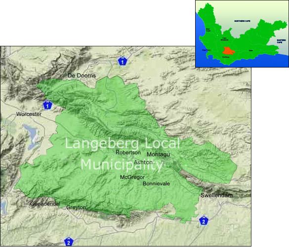
The municipality covers a land area of 4,518 square kilometres (1,744 sq mi) in the Breede River Valley and the west end of the Little Karoo. The Langeberg mountains run from northwest to southeast through the centre of the municipality, and the Breede River flows in the same direction south of the Langeberg. The Riviersonderend Mountains form the southern boundary of the municipality and the Koega Mountains form the northern boundary. It abuts on the Breede Valley Municipality to the northwest, the Laingsburg and Kannaland Municipalities to the northeast, the Swellendam Municipality to the southeast, and the Theewaterskloof Municipality to the southwest.
According to the 2011 census the municipality has a population of 97,724 people in 25,125 households. Of this population, 70.3% describe themselves as "Coloured", 16.3% as "Black African", and 12.3% as "White". The first language of 82.5% of the population is Afrikaans, while 10.7% speak Xhosa, 3.1% speak English and 1.3% speak Sotho.
The largest town in the municipality is Robertson, which as of 2011 has a population of 27,715. Montagu (pop. 15,176) is situated on the northeastern side of the Langeberg at the entrance to the Cogmanskloof gorge, while Ashton (pop. 13,325), the site of the municipal headquarters, is situated on the other side of the mountains at the gorge's exit. Bonnievale (pop. 9,092) is on the Breede River downstream from Robertson and Ashton, and McGregor (pop. 3,125) is south of Robertson in the foothills of the Riviersonderend Mountains.
Politics
The municipal council consists of twenty-three members elected by mixed-member proportional representation. Twelve councillors are elected by first-past-the-post voting in twelve wards, while the remaining eleven are chosen from party lists so that the total number of party representatives is proportional to the number of votes received.
In the election of 18 May 2011 no party won a majority on the council. The Democratic Alliance (DA) with eleven seats formed a coalition with the Congress of the People (COPE) which holds one seat. The mayor of the municipality is Diana Gagiano of the DA.
The following table shows the results of the 2011 election.
The local council sends three representatives to the council of the Cape Winelands District Municipality: two from the Democratic Alliance and one from the African National Congress.