
 | ||
australia tour lanes and arcades of melbourne hidden secrets
The lanes and arcades of Melbourne, Australia, have collectively become culturally important.
Contents
- australia tour lanes and arcades of melbourne hidden secrets
- Map of Hosier Ln London EC1A 9LQ UK
- ACDC Lane
- Bank Place
- Bligh Place
- The Block Arcade
- Block Place
- Caledonian Lane
- Cathedral Arcade
- Causeway Lane
- Centre Place
- Corporation Lane
- Dame Edna Place
- Degraves Street
- Flinders Lane
- Hardware Lane
- Hosier Lane
- Howey Place
- History
- Niagara Lane
- McKillop Street
- Melbourne GPO
- Royal Arcade
- References
Map of Hosier Ln, London EC1A 9LQ, UK
The Melbourne central business district's numerous lanes mostly date to the Victorian era and as a result of the original Hoddle Grid, they evolved as service laneways for horses and carts. In some parts of the city, notably Little Lonsdale area, they were associated with the city's gold rush era slums. Among the most notable are Centre Place and Degraves Lane. Melbourne's numerous shopping arcades reached a peak of popularity in the late Victorian era and the interwar years. Among the most notable include Block Place and Royal Arcade. Some notable demolished arcades include Coles Book arcade and Queens Walk arcade.
Since the 1990s, Melbourne's lanes, particularly the pedestrianised ones, have gentrified and their heritage value officially recognised as well as attracting interest from Australia and around the world. Some of the lanes, in particular have become particularly notable for their acclaimed urban art.
The city has several festivals which celebrate the laneways, they are major tourist attractions and frequently feature in tourism promotions, film and television.
ACDC Lane
ACDC Lane is a short, narrow laneway, running south from Flinders Lane between Exhibition Street and Russell Street.
The street was formerly called Corporation Lane, but was renamed on 1 October 2004 as a tribute to Australian rock band AC/DC. The Melbourne City Council's vote to rename the street was unanimous. The trademark lightning bolt or slash ("/") used to separate the AC and the DC in the band's name contravened the naming policy of the Office of the Registrar of Geographic Names, so the punctuation was omitted on the street sign.
Melbourne's Lord Mayor John So launched ACDC Lane with the words, "As the song says, there is a highway to hell, but this is a laneway to heaven. Let us rock." Bagpipers then played "It's a Long Way to the Top (If You Wanna Rock 'n' Roll)." One month after the renaming, a lightning bolt was erected above and below the street sign. The lighting bolt was removed at a later date.
The lane contains a rock 'n' roll nightclub called the Cherry Bar.
Corporation Lane was chosen for renaming in part because the band filmed the music video for "It's a Long Way to the Top (If You Wanna Rock 'n' Roll)" on Melbourne's Swanston Street. ACDC Lane is near Swanston Street.
Other factors given include: AC/DC's status as cultural ambassadors for Australia, the band's ties to Melbourne, and the lane's position in the city's bar district.
Bank Place
Bank Place is a street in Melbourne, Victoria. It is a short, narrow laneway, running south from Little Collins Street between Queen Street and William Street.
Located in the heart of the financial sector, Bank Place (which incorporates several smaller lanes, such as Mitre Lane) is an oasis of heritage pre-war buildings dating from the 1860s through to the 1920s. Looking north, a vista is framed by Normanby Chambers.
The precinct is subject to heritage restrictions, and some of the significant buildings include:
Some significant buildings include 12-16 Bank Place was built 1884 - 85 for Australia's first baronet Sir William Clarke. His son, Sir Rupert Clarke's mistress Connie Waugh is said to have lived there. The Melbourne Savage Club purchased the building in 1923. The building is classified by the National Trust of Australia (Victoria). Stalbridge Chambers built in 1891 is on the corner of Little Collins. Charter House is another notable old building in the lane.
The lane also includes several ornate heritage lamp posts and bluestone alleys.
Bank Place is home to several popular bars and cafes which serve many of the nearby office workers. Many of the taller old buildings have been converted into loft style apartments.
Bligh Place
Bligh Place is a short, quiet and narrow open laneway, running north from Flinders Lane between Elizabeth Street and Queen Street.
Located near Victoria University and the financial centre of Melbourne, Bligh Place is a short lane which connects across Flinders Lane with University Place and University Arcade through to Flinders Street. As such, it is popular with students and is currently flanked by some small noodle, sushi, cafes and wine bars.
The lane was developed in the 1990s following the location of Victoria University to the inner city campus and has a heritage building which was restored in the late 1990s on the eastern entrance and some converted warehouse lofts apartments. A vista is created by the Victoria University campus to the south on Flinders Street.
The lane is bitumen with a small strip blue stone cobbled gutter, has suspended overhead lighting and is unused by vehicular traffic.
The Block Arcade
The Block Arcade is a heritage shopping arcade that forms a short, narrow laneway, connecting Collins Street to Little Collins Street in the central business district of Melbourne. It is also connected to Elizabeth Street in the west, thus, forming a L-shaped arcade and connecting to Block Place through to the Royal Arcade.
Melbourne's Golden Mile heritage walk runs through the arcade.
The arcade which was erected between 1891 and 1893 was designed by architect David C. Askew whose brief was to produce something similar to the Galleria Vittoria in Milan. The result was one of Melbourne's most richly decorated interior spaces, replete with mosaic tiled flooring, glass canopy, wrought iron and carved stone finishings. The exterior façade of the six storey office has near identical facades on Collins and Elizabeth Streets and is one of Australia's best surviving examples of the Victorian Mannerist style.
The arcade was formerly known as "Carpenter's Lane", however the precinct was widely known as "The Block". Once the works were complete, local shopkeepers successfully petitioned to have it changed to its present name.
It is a significant Victorian era arcade and is on the Victorian Heritage Register. Along with Melbourne's other main arcade, the Royal Arcade, and Melbourne's lanes, it is a tourist icon of the city.
Block Place
Block Place is a short, narrow partially covered laneway, running south from Little Collins Street between Swanston Street and Elizabeth Street.
Block Place is a pedestrian only laneway that is trendy and popular with both Melbourne locals and tourists for its intimate alfresco cafes close to the shopping heart of Melbourne it is crowded with cafes and shops in a number of pre-war buildings. Cafe Segovia is one of a popular lunch destination and a popular record store is located in underground basements.
The lane joins with the heritage Block Arcade, a 19th-century covered shopping arcade. Block Arcade and Block Place form a T-shape running from Little Collins Street through to Collins Street and Elizabeth Street.
Royal Arcade is just across Little Collins and connects through to Bourke Street.
Caledonian Lane
Caledonian Lane is a short, quiet and narrow (4 metre wide) open laneway, running north from Little Bourke Street between Little Bourke Street and Lonsdale Street.
Caledonian Lane is most notable as the former home to the St Jerome's Laneway Festival. It is also notable due to controversial developments in 2009 involving the redevelopment of the Post Office precinct and Department Store precinct also involving the shutting down of both St Jerome's and the festival.
A consortium involving Myer and Colonial First State applied for exemption from the City of Melbourne Heritage Overlay to widen the lane by 4 metres to improve access for delivery trucks and in the process demolish the art deco landmark Lonsdale House in 2009. Permission was granted by both the City of Melbourne and the State planning minister Justin Madden MP on 24 July 2009 under controversial circumstances. In response to the demolition for the sake of lane widening, a preservation group called Save Lonsdale House formed in late 2009 despite protests the building was demolished in 2010 and the lane was widened.
Until 2004, Caledonian Lane was home to a number of small independent store owners, however the buildings were sold under vacant possession in 2007.
The lane is bitumen with a small strip blue stone cobbled gutter, has street lighting attached to Lonsdale House and is by both pedestrian and vehicular traffic, mainly delivery trucks. Caledonian Lane forms a vista toward both Loudon Place to the south and Drewery Lane to the north, both are almost directly opposite.
Cathedral Arcade
Cathedral Arcade is a heritage shopping arcade forming a short, narrow laneway, connecting Swanston Street to Flinders Lane. It is a T-shaped arcade, however one of the laneways terminates inside of the building.
The arcade is notable as it retains all of its original features. The arcade is fully covered by stained glass and leadlights, which forms a highly detailed arch leading to a central dome. The floors are decorated with ceramic tiles, and the shopfronts feature richly detailed wood panels.
The art deco arcade, which dates back to 1925 is part of the Nicholas Building designed by Harry Norris, is an early interwar palazzo skyscraper. The building itself, including the arcade is listed on the Victorian Heritage Register.
Causeway Lane
Causeway Lane (also known as The Causeway) is a short, quiet and narrow open laneway, running between Bourke Street Mall and Little Collins Street between Elizabeth Street and Swanston Street.
Located in the heart of the shopping precinct, the Causeway is currently flanked by some small boutique shops, indoor and outdoor cafes and sushi bars.
The lane is notable for the heritage listed former Union Bank a tall curved palazzo styled building constructed in the 1920s which has a mezzanine entrance at the corner of the lane. The building is now occupied by Laurent, an upmarket French patisserie.
The lane is bitumen and lined by the plain sides of some heritage buildings. It is closed to all vehicular traffic.
A vista is created at either end by the Myer Emporium on Bourke Street Mall and at the other by the postmodern facade of the Novotel on Collins.
Centre Place
Centre Place is a busy laneway and arcade that runs between Flinders Lane and Collins Street.
The laneway is home to several vibrant bars, cafes, restaurants, boutiques, sushi bars and shops, as well as some of Melbourne's best examples of street art and graffiti, particularly stencil graffiti, known as "City Lights". This precinct has been used in tourist promotion campaigns for the city.
Corporation Lane
Many minor laneways in Melbourne are given the 'default' name "Corporation Lane". Often these "unnamed" laneways do not appear in street directories. Progressively some of these have been renamed to something 'novel', often commemorative. The most famous example is ACDC Lane. However several other examples exist, including Menzies Lane, East Melbourne.
Because of the number of 'Corporation Lanes', they are identified by number. For example, the lane that became Menzies Lane was previously listed as "Corporation Lane (No. 1161)". An article in The Age revealed that: "Of the 1556 laneways in the City of Port Phillip, for example, most are numbered but few are named."
Dame Edna Place
Dame Edna Place (formerly Brown Alley) is a lane off Little Collins Street. It was renamed in honour of Dame Edna Everage in 2007 and officially opened by the Lord Mayor John So. Dame Edna Place is opposite Royal Arcade and The Causeway, between the major roads, Elizabeth Street and Swanston Street; it was, until its renaming, a service alley for adjoining buildings. Dame Edna was not at the renaming ceremony but was represented by ten look-alike Dames.
Degraves Street
Degraves Street is a short, narrow laneway, running north from Flinders Street to Flinders Lane
It was named after Charles and William Degraves, pioneer merchants who settled in Melbourne from Hobart, Tasmania in 1849. William Degraves (1821–1883) was also a large-scale grazier and a member of Victoria's Legislative Council between 1860 and 1874.
The cobbled bluestone alley forms a busy alternative thoroughfare for commuters disembarking from Flinders Street Station toward the shopping areas of The Block on Collins Street and Bourke Street Mall, loosely connecting with Centre Place, a similar lane just across Flinders Lane. The Degraves underpass was built in the 1950s, one of the few public works at the time, to allow pedestrians to get from Flinders Street Station to Degraves street rather than have to walk across busy Flinders Street. Degraves underpass is also home to Platform Artists Group, and frequently presents new works. Vehicles have only restricted access.
The lane features bars, cafes, and restaurants and many of the taller old buildings have been converted into loft style apartments in the 1990s, adding further life to the street.
Redevelopment of the Mutual Store in 2006 has further enhanced the lane with additional shops.
A vista up Degraves laneway is created by "Majorca House", an ornate 1930s building dressed in faience.
People use Degraves Street as a quick stop for a coffee before going to catch their train at Flinders Street Station.
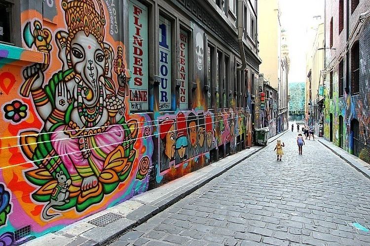
Flinders Lane
Flinders Lane is a minor street. The street runs parallel to and to the north of Flinders Street and as a narrow one way lane takes on the name of the wider main street. The street was the centre of Melbourne's rag trade for the middle decades of the 20th century and is still home to small boutique designers.
The lane has been spared the overdevelopment of nearby Collins Street, with many of these buildings historically subject to strict height limits of around 40 metres. Despite the loss of some significant turn of the century buildings, it is now known for its "SoHo" atmosphere. Today, the area is home to many boutique hotels, "loft style" apartment conversions, cafes and bars as well as connecting with a number of smaller lanes, including Degraves Street, ACDC Lane, Manchester Lane and Centreway which weave their way through the city.
For a block between William Street and Market Street, Melbourne tram route 55 runs along Flinders Lane.
Hardware Lane
Hardware Lane runs roughly north-south between Bourke Street and Little Lonsdale Street. Restaurants and ski shops are located on the street, as well as hairdressers. A McDonald's franchise is located at the southern end of the street, with other fast food restaurants.
The lane is closed to traffic and at night live jazz entertains visitors to bars and cafés.
Named after Hardware House in the 1920s, Hardware Lane was built on land formerly occupied by Kirk's Horse Bazaar, a horse and livery trading centre built in 1840 by James Bowie Kirk [1].
Dynon's Building at 63-73 Hardware Lane is a set of four warehouses designed by William Pitt, the designer of some of the finest gothic revival buildings in the city including Princess Theatre.
Hosier Lane
Hosier Lane is a bluestone cobbled vehicular and pedestrian laneway on the southern edge of the central city grid. Hosier lane is a much celebrated landmark mainly due to its sophisticated Urban art.
Hosier Lane lies opposite the entrance to the Atrium at Federation Square on Flinders St, a prominent position in the city.
The lane has been noted for the quality and the often political nature of its art. It features in the state-sponsored book The Melbourne Design Guide and in Tourism Victoria's Lose Yourself in Melbourne advertising campaign, leading to questions about the dichotomy of Victoria's approach to graffiti. The graffiti-covered walls and art-installations have become a popular backdrop for fashion and wedding photography.
Hosier Lane is also known for its upmarket cocktail lounges including the popular Misty and MoVida. An open air cooking session with MoVida's chef Frank Camorra on Masterchef Australia season 2 showcased the lane as a major Melbourne attraction.
Howey Place
Howey Place, formerly known as "Cole's Walk" is a shopping arcade. The short, narrow covered laneway, running south from Little Collins Street between Swanston Street and Elizabeth Street.
Located in the heart of the shopping precinct, Howey Place is currently flanked with small designer fashion shops. It joins with the Sportsgirl Centre, a shopping mall at 234 Collins Street which runs through to Collins Street, as well forming an "L" shape toward the back of the Capitol Arcade which connects it with Swanston Street.
Motor vehicles are restricted access.
History
Before 1896, Howey Place was just a drab lane. In 1896, Edward William Cole, the developer of the famous Cole's Book Arcade, covered the lane with a glass canopy and created glass showcases along the street to attract tenants which included a Cole's wholesale bookstore, a toy department store and printing shop.
In the 1920s, the streamline moderne Presgrave building was incorporated into the lane.
Howey House, a tall art-deco building and part of the Collins Street in the 1930s once connected the lane to Collins Street via an open laneway, however Howey House was demolished in the 1980s for the construction of the Sportsgirl Centre, a modern shopping mall.
Niagara Lane
Niagara Lane is a small lane running roughly north-south between Bourke Street and Little Bourke Street. The lane is named after the Niagara buildings, early 20th century warehouses which feature their row of original pulley and hook stocking systems from horse and cart days.
The lane is lined by pre-war buildings, is cobbled in bluestone and is accessible to pedestrians and small vehicles. It has a southward vista dominated by the copper dome topped post modern tower 333 Collins Street and Eureka Tower.
On the western corner of Lonsdale Street is the Niagara Hotel. This facade of this 1870s hotel was modified and modernised in the 1920s.
McKillop Street
McKillop Street is a short, quiet and narrow open laneway, running between Bourke Street and Little Collins Street between Queen Street and Elizabeth Street in the central business district of Melbourne.
Located between the financial centre and shopping precinct, McKillop Street is currently flanked by some small boutique shops and outdoor dining cafes.
The lane is paved with red brick, has several trees and heritage style lampposts along it and restricted access to cars. There are some heritage buildings converted into apartments along the street.
Melbourne GPO
The Melbourne General Post Office or GPO, is a landmark building on the corner of Elizabeth Street and Bourke Street that was restored as a retail centre in 2004 and now forms a major arcade running from Bourke Street through to Little Bourke Street.
Royal Arcade
Royal Arcade is a heritage shopping arcade originally constructed in 1869, the arcade connects Little Collins Street to the Bourke Street Mall, with a perpendicular passage running to Elizabeth Street in the west. It also connects to the smaller Hub Arcade near the Little Collins Street end.
Originally designed by Charles Webb, the arcade features a high glass roof and windowed stores. At the south end, the arcade features effigies of mythical figures Gog and Magog and a clock which chimes each hour. The arcade was restored between 2002 and 2004 which resulted in additional natural light and consistency of the shopfronts.
It is a significant Victorian era arcade, recorded on the Victorian Heritage Register. In addition, Melbourne's Golden Mile heritage walk runs through the arcade.
Along with Melbourne's other arcade, the Block Arcade, and Melbourne's lanes, it is a tourist icon of the city. Royal Arcade is famous for its fashion stores as well as specialty stores such as tarot card reading store.