
Mission type Earth imaging COSPAR ID 1978-026A Launch date 5 March 1978 Inclination 99.1° Rocket Delta 2000 | SATCAT no. 10702 Inclination 99.1° Period 1.7 hours | |
 | ||
Mission duration 5 years, 6 months, 2 days Launch mass 960.0 kilograms (2,116.4 lb) Similar | ||
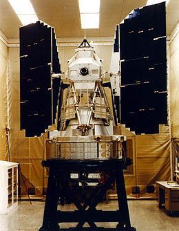
Landsat 3 is the third satellite of the Landsat program. It was launched on March 5, 1978, with the primary goal of providing a global archive of satellite imagery (satellite data are called images and not photos because they are not just reflected light exposure, but recordings of radiative electromagnetic energy fluxes of surface materials). Unlike later Landsats, Landsat 3 was managed solely by NASA. Landsat 3 is no longer in operation, having been decommissioned on September 7, 1983, far beyond its designed life expectancy of one year.
Specifications
Landsat 3 had essentially the same design as Landsat 2. It carried a Multi-Spectral Scanner, which had a maximum 75 meters (246 ft) resolution. Unlike the previous two Landsat missions, a thermal band was built into Landsat 3's Multi-Spectral Scanner, but this instrument failed shortly after the satellite was deployed. Landsat 3 was placed into a polar orbit at about 920 kilometers (570 mi), and took 18 days to cover the entire Earth's surface.