
Admin. region Niederbayern Elevation 390 m (1,280 ft) Area 84.37 km² Local time Sunday 9:05 AM Dialling code 09951 | Time zone CET/CEST (UTC+1/+2) Population 12,741 (31 Dec 2008) Postal code 94405 Administrative region Lower Bavaria | |
 | ||
Weather 4°C, Wind E at 11 km/h, 74% Humidity | ||
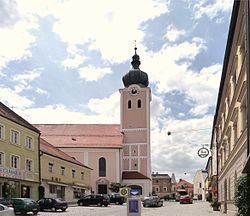
Landau an der Isar (official name: Landau a.d.Isar) is the second largest town in the Lower Bavarian district, or Landkreis, of Dingolfing-Landau, in the state of Bavaria, Germany. It lies on the river Isar. In 2005, the population was around 12,950.
Contents
- Map of 94405 Landau an der Isar Germany
- History
- Former Landauers
- Honorary town citizens
- Sights to see
- Economy prominent companies
- Trafficroadways
- Government offices
- References
Map of 94405 Landau an der Isar, Germany
History
Landau was founded in 1224 by the Wittelsbach Ludwig I, Duke of Bavaria. The town had been a Pflegamt for many years and belonged to the Landshut Rentamt of the Electorate-Principality (Kurfürstentum) of Bavaria. Landau possessed a town court with broad magisterial powers (Landgericht).
Until the Bavarian county reform, or Kreisreform in German, in 1972, Landau was the district seat (Kreisstadt) of its own Landkreis, having the license plate code LAN. In the reform, the former townships of Frammering, Mettenhausen, Reichersdorf and Zeholfing, along with parts of the townships of Kammern and Ganacker, were merged with the town of Landau. The incorporation of the townships of Nieder- and Oberhöcking followed in 1978.
Former Landauers
Honorary town citizens
Sights to see
Economy: prominent companies
Traffic/roadways
The town is bound by the Bundesstraße 20 and the Bundesautobahn 92 and lies on the train line Landshut–Wörth a.d.Isar–Dingolfing–Landau a.d.Isar–Wallersdorf–Plattling.