
Admin. region Niederbayern Time zone CET/CEST (UTC+1/+2) Area 44.04 km² Local time Tuesday 11:43 PM Dialling code 08731 | District Dingolfing-Landau Postal codes 84130 Population 19,145 (31 Dec 2015) Postal code 84130 | |
 | ||
Weather 3°C, Wind W at 10 km/h, 90% Humidity | ||
Dingolfing is a town in Southern Bavaria, Germany. It is the seat of the Landkreis (district) Dingolfing-Landau.
Contents
- Map of 84130 Dingolfing Germany
- History
- Geography
- Important buildings
- Economy
- People from Dingolfing
- Literature
- References
Map of 84130 Dingolfing, Germany
History
The area now called Dingolfing was first mentioned in Tinguluinga in the year 833.
In the year 1251 the duke of Bavaria, Otto II awarded municipal rights to the town, which was the Upper City. The Lower City, around the church of St. John's, was an older settlement belonging to the Prince-Bishopric of Regensburg. By treaty of 1265 between Duke and Bishop, both cities were united.
Dingolfing's large growth took place during the years of about 1315 to 1600. During this time the city prospered mostly through trade, fishing, leather craft and the production of wool cloths. The duke promoted these works, causing Dingolfing to prosper even more.
The war of Austrian succession caused very heavy damage to the city and decimated the population by epidemics. The city became nothing more than debris and ash on May 16, 1743 after being fired upon by Austrian troops. Greater parts of the city were burnt in a large fire. Many of the town's records were destroyed in this fire.
Between 1802 and 1803 the local courts were dissolved. Between 1816 and 1817 there were many economic and harvest failures. There was also a period of large price increases. This period is thought to be the lowest point in the long history of the city.
A railroad track leading from Munich to Prague and many new roads were built in the mid-19th century, which began a major turn-around for the city. Many new industries formed in Dingolfing around this time too. The region began to paint a new picture of itself.
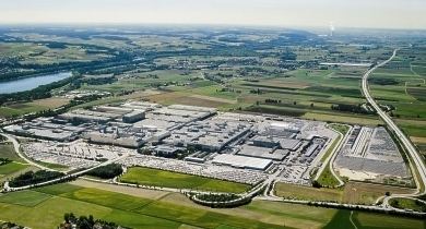
In 1905 a new machine shop opened to repair broken farming equipment. After the Second World War this shop changed its business and began producing scooters and automobiles. In the 1950s this plant began producing automobiles under the Glas car company. Bavarian Motor Works (BMW), from which the city prospers greatly today, bought this plant in 1967.
After 1945 and especially since the 1970s Dingolfing intensified its investments in its urban infrastructure, including schools, hospitals, and housing for the elderly.
Geography
Dingolfing is located on the Isar river. Dingolfing is about 100 km northeast of Munich, the capital of the German state of Bavaria, and about 30 km east of Landshut and 25 km south of Straubing. The Isar divides the city into the older historical section of the city on the right side of the river (historically divided into the Upper City and the Lower City), and the area of the former farming villages Goben, Geratsberg, Höll and Sossau, where much residential development in recent decades has grown to a newer section of the city on the left side of the river.
Important buildings
Economy
The most important industry in the Dingolfing-Landau region is automobile construction. Dingolfing is home to BMW's largest production facility which produces around 270,000 cars (BMW 5, 6, 7 series and also the M5 and M6) each year.