
Intercommunality Plabennec et des Abers Area 10.98 km² | Canton Lannilis Population (2008) 3,628 Local time Sunday 11:52 AM | |
 | ||
Weather 11°C, Wind NW at 39 km/h, 83% Humidity Points of interest Fort Cézon, Plage des Anges, Plage Plougouri, Ile Cézon, Ancienne caserne de douaniers | ||
Landéda (Breton: Landeda) is a commune in the Finistère department of Brittany in north-western France.
Contents
- Map of 29870 LandC3A9da France
- Geography
- History
- Population
- Sea rescue
- Economy
- Sights
- Associations
- References
Map of 29870 Land%C3%A9da, France
Geography
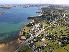
The coastal commune of Landéda forms a peninsula between two rias, the Aber Wrac'h to the north and the Aber-Benoît to the south.
History
Population
Inhabitants of Landéda are called in French Landédaens.
Sea rescue
Landeda is the base for the high-speed rescue motorboat located at the port of Aber Wrac'h. The rescue service is operated by volunteers. The rescue motorboat is named the President Joseph Oulhen, which is the name of a former manager of the service who died in service in 1986.
Economy
The port of the Aber Wrac'h is within the territory of the commune. It includes a marina managed by the Chamber of Commerce and Industry of Brest.
Sights
Other notable sights include an abbey, a manor, many stone crosses and islands with ancient ruins.