
Country Nepal Time zone NPT (UTC+5:45) Website Official website Zone Gandaki Zone | Main language(s) nepali, gurung, magar Area 1,692 km² | |
 | ||
Region Western Development Region, Nepal | ||
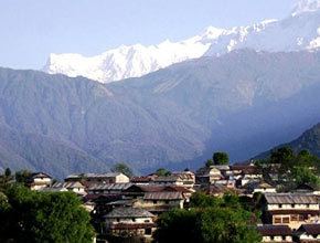
Ghalegaun bhujung visit 2072 mlp sba hdcs lamjung district community hospital
Lamjung District (Nepali: लमजुङ जिल्ला Listen ), a part of Province No. 4, is one of the seventy-five districts of Nepal, a landlocked country of South Asia. The district, with Besisahar as its district headquarters, covers an area of 1,692 square kilometres (653 sq mi) and as of 2011 had a population of 167,724. Lamjung lies in the mid-hills of Nepal with spanning from tropical to trans-himalyan geo-ecological belts,including the geographical midpoint of the country(ie.Duipiple). It has mixed habitation of different cast and ethnicity - host probably the highest density of Gurung ethnic population in the country.
Contents
- Ghalegaun bhujung visit 2072 mlp sba hdcs lamjung district community hospital
- Map of Lamjung Nepal
- 2015 earthquake
- References
Map of Lamjung, Nepal
2015 earthquake
The epicentre of an earthquake on 25 April 2015 was near Lamjung District. Most of the major damage and casualties took place in nearby Kathmandu, Nepal's capital. The death toll for the earthquake was placed at over 8,800. However, only four deaths were reported in Lamjung District. While Lamjung is the district with the 20th most deaths in Nepal, it been severely damaged. The villages of Bichaur, Ilampokhari, Dudhpokhari, Gauda, Kolki and Pyarjung are the most affected in Lamjung district. Assistant Sub Inspector Bir Bahadur Thapa Magar has identified the four deaths in Lamjung District as Lakshmi Gurung, 18, of Ilampokhari village, Nepti Tamang, 91, of Gaudu village, Sher Bahadur Tamang, 62, of Gaudu village and three-and-a-half month old Sumit Bika of Gauda village. Twenty-five people were injured in Lamjung District. Local police estimate 2,094 houses were completely destroyed while another 2,129 houses were partially damaged in Lamjung District.