
OS grid reference TQ479961 Sovereign state United Kingdom | Civil parish Lambourne Area 10.5 km² | |
 | ||
Population 1,828 (2001)2,013 (2011) | ||
Lambourne is a civil parish in the Epping Forest district of Essex, England. It is located approximately 4.5 miles (7 km) South of Epping and 5 miles (8 km) northwest of Romford, it is situated entirely within the M25 motorway. It covers an area of 2,590 acres (1,050 ha), and in 2001 its population was 1,828, increasing to 2,013 at the 2011 Census.
Contents
Map of Lambourne, UK
History
Like much of the neighbouring area, Lambourne was thickly wooded in the Middle Ages with forest gradually being cleared for agriculture. A few remnants of the historic Hainault Forest are found in the southern fringe of the parish, and now form part of a country park.
Its population was 505 in 1801 rising to 904 by 1841, remaining at about that level for the next century.
Historically Lambourne was included in the hundred of Ongar. It formed part of the Ongar Rural District from 1894 to 1955, and then Epping and Ongar Rural District until it became part of Epping Forest District in 1974.
Geography
The parish is mostly rural and agricultural, and lies in the valley of the River Roding which forms the northern boundary of the parish. The parish is mostly hilly, rising to above 100 metres in its centre. There is no actual village called Lambourne, however the principal settlement is the village of Abridge in the far northwest of the parish, with the other main concentration of houses at the hamlet of Lambourne End to the south. A scattering of farms and houses is found throughout the rest of the parish. To the south of the parish is Hainault Forest Country Park, managed by the Woodland Trust which also extends into Greater London. For postal addresses, the parish is within the RM4 postcode district of the Romford post town.
Landmarks
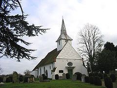
The mediaeval parish church of St Mary is in an isolated location next to the Hall, as is typical for Essex, rather than near a centre of population. It has an unusual Georgian internal remodelling.
Transport
Stapleford Aerodrome is located in the east of the parish. Another aviation connection is its status as the location of LAM, a VOR navigational beacon which anchors the North East (NE) Arrival Stack for London Heathrow Airport (ICAO: EGLL / IATA: LHR), which along with Biggin Hill (BIG - SE Arrivals), Bovingdon, Hertfordshire (BNN - NW Arrivals) and Ockham, Surrey (OCK - SW Arrivals) are London's main holds.