
- average 1.85 m/s (65 cu ft/s) Source Great Dunmow Country United Kingdom | - elevation 93 m (305 ft) - elevation 0 m (0 ft) Discharge 1.85 m³/s | |
 | ||
- max 62.4 m/s (2,204 cu ft/s) 22 November 1974 | ||
The River Roding is a river in England that rises at Molehill Green near Dunmow in Essex. It then flows south through Essex and forms Barking Creek as it reaches the River Thames in part of the county that since 1965 has also been part of Greater London.
Map of River Roding, United Kingdom
The river leaves Dunmow and passes through or near a group of villages in Essex known collectively as the Rodings, as they all end with the suffix 'Roding'. After Chipping Ongar, the river flows under the M25 motorway by Passingford Bridge and Abridge.
The river then runs past Loughton and between Chigwell and Woodford Green where the Roding Valley Meadows make up the largest surviving area of traditionally managed river-valley habitat in Essex. This nature reserve consists of unimproved wet and dry hay meadows, rich with flora and fauna and bounded by thick hedgerows, scrubland, secondary woodland and tree plantation. The meadows stretch down to the M11 motorway and Roding Valley tube station is situated close to the area, although Loughton or Buckhurst Hill are better placed for a visit.
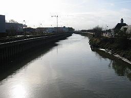
Redbridge takes its name from a crossing of the river which then passes through Ilford and Barking. The River Roding through Ilford project is a government backed scheme to improve amenities along this stretch of the river. After Barking the tidal section is known as Barking Creek, which flows into the Thames at Creekmouth.
In Essex the river forms part of the boundary between the district of Epping Forest and borough of Brentwood. The river marks much of the boundary between the London Borough of Newham and the London Borough of Barking and Dagenham. Ilford takes its name from Ilefort, "ford on the River Hyle", which was the mediaeval name for part of the Roding.