
Elevation 628 m Country United States of America | ||
 | ||
The Lakeview Mountains are a range of low mountains encompassing approximately 30 square miles (80 km2) of land in western Riverside County, Southern California, at the northern end of the Peninsular Ranges System.
Contents
Map of Lakeview Mountains, California 92567, USA
GeographyEdit
The Lakeview Mountains are bordered:
The highest point in the Lakeview Mountains is at elevation 2,673 feet (815 m) above mean sea level. Mount Rudolph, a prominent feature at the northerly end of the range, rises to an elevation of 2,595 ft (791 m).
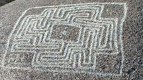
Reinhardt Canyon, on the easterly side of the range, is the home of the prehistoric petroglyph known as the Hemet Maze Stone (California Historical Landmark No. 557).
Natural historyEdit
The vegetation of the Lakeview Mountains consist primarily of the Coastal Sage Scrub and Montane chaparral and woodlands plant communities.
The Lakeview Mountains are the primary visible trace of the Lakeview Mountains Pluton, consisting primarily of Cretaceous tonalite.